Povljana geodata
Povljana (Zadarska) is a seat of a second-order administrative division; located in Croatia in Europe/Zagreb (GMT+2) time zone. In our database, there are 904 cities with bigger population. Compared to other cities in Croatia, 79.9% of cities are located further ↑North; 88.4% of cities are located further →East and 88.3% of cities have higher elevation than Povljana. Note1


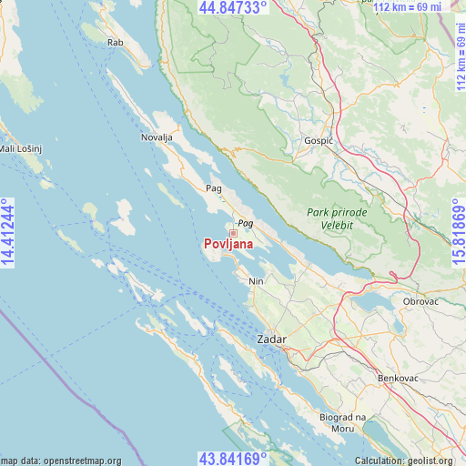
Povljana GPS coordinates[2]
44° 20' 48.012" North, 15° 6' 56.016" East
| Map corner | latitude | longitude |
|---|---|---|
| Upper-left | 44.84733°, | 14.41244° |
| Center: | 44.34667°, | 15.11556° |
| Lower-right: | 43.84169°, | 15.81869° |
| Map W x H: | 111.8×111.8 km | = 69.5×69.5mi |
| max Lat: | 46.52694° ⇑79.9% North |
| Povljana: | 44.34667° |
| min Lat: | ⇓20.1% South 42.54972° |
| min Long | Povljana | max Long |
| 13.52389° | 15.11556° | 19.37694° |
| W 11.6%⇐ | ⇒88.4% E |
Elevation
Elevation of Povljana is 31 m = 102 ft, and this is 122.3 m = 401 ft below average elevation for this country.
| Max E: |
827 m = 2713 ft | 88.3% |
| Avg. | 153.3 m = 503 ft | |
| Povljana | 31 m = 102 ft | |
Min E: |
-1 m = -3 ft | 11.7% |
See also: Croatia elevation on elevation.city.
Geographical zone
Povljana is located in North temperate zone (between Tropic of Cancer and the Arctic Circle). Distance of this Northern Tropic circle is 2325 km =1444.7 mi to South.| Distance of | km | miles | from Povljana |
|---|---|---|---|
| North Pole | 5076.2 | 3154.2 | to North |
| Arctic Circle | 2470.3 | 1535 | to North |
| Tropic Cancer | 2325 | 1444.7 | to South |
| Equator | 4930.9 | 3063.9 | to South |


Nearby cities:
15 places around Povljana: (largest is in red/bold)
• Briševo
25.4 km =15.8 mi,  143°
143°
• Karlobag
20.4 km =12.7 mi,  350°
350°
• Kolan
20.5 km =12.7 mi,  323°
323°
• Kožino
20.6 km =12.8 mi,  161°
161°
• Nin
12.7 km =7.9 mi, 156°
• Pag
11.9 km =7.4 mi,  337°
337°
• Privlaka
9 km =5.6 mi,  170°
170°
• Radovin
24.7 km =15.3 mi,  121°
121°
• Ražanac
19.8 km =12.3 mi,  111°
111°
• Stari Grad
10.2 km =6.3 mi, 335°
• Starigrad
26.3 km =16.3 mi,  102°
102°
• Ugljan
24 km =14.9 mi,  182°
182°
• Vir
5.4 km =3.4 mi,  206°
206°
• Vrsi
13 km =8.1 mi,  134°
134°
• Zaton
14.8 km =9.2 mi, 161°
Sources, notices
• [Note1] Compared only with cities in Croatia existing in our database
• [Src1] Map data: © OpenStreetMap contributors (CC-BY-SA)
• [Src2] Other city data from geonames.org with taken over terms of usage.
• [Src3] Geographical zone / Annual Mean Temperature by Robert A. Rohde @ Wikipedia
