Pag geodata
Pag (Zadarska) is a seat of a second-order administrative division; located in Croatia in Europe/Zagreb (GMT+2) time zone. With population of 2,714 people, there are 158 cities with bigger population in this country. Compared to other cities in Croatia, 79.6% of cities are located further ↑North; 89% of cities are located further →East and 91.1% of cities have higher elevation than Pag. Note1


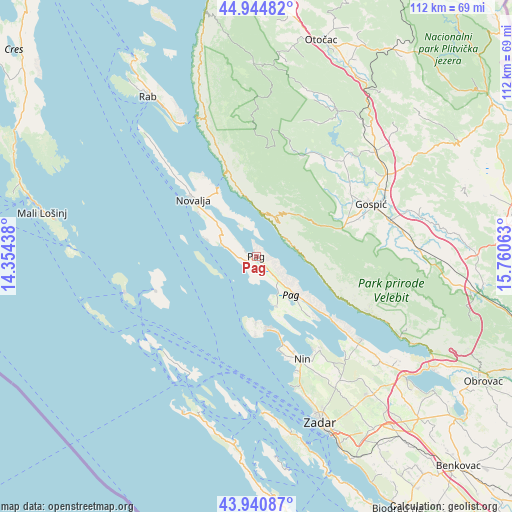
Pag GPS coordinates[2]
44° 26' 42" North, 15° 3' 27" East
| Map corner | latitude | longitude |
|---|---|---|
| Upper-left | 44.94482°, | 14.35438° |
| Center: | 44.445°, | 15.0575° |
| Lower-right: | 43.94087°, | 15.76063° |
| Map W x H: | 111.6×111.6 km | = 69.3×69.3mi |
| max Lat: | 46.52694° ⇑79.6% North |
| Pag: | 44.445° |
| min Lat: | ⇓20.4% South 42.54972° |
| min Long | Pag | max Long |
| 13.52389° | 15.0575° | 19.37694° |
| W 11%⇐ | ⇒89% E |
Elevation
Elevation of Pag is 18 m = 59 ft, and this is 135.3 m = 444 ft below average elevation for this country.
| Max E: |
827 m = 2713 ft | 91.1% |
| Avg. | 153.3 m = 503 ft | |
| Pag | 18 m = 59 ft | |
Min E: |
-1 m = -3 ft | 8.9% |
See also: Croatia elevation on elevation.city.
Geographical zone
Pag is located in North temperate zone (between Tropic of Cancer and the Arctic Circle). Distance of this Northern Tropic circle is 2335.9 km =1451.5 mi to South.| Distance of | km | miles | from Pag |
|---|---|---|---|
| North Pole | 5065.2 | 3147.4 | to North |
| Arctic Circle | 2459.4 | 1528.2 | to North |
| Tropic Cancer | 2335.9 | 1451.5 | to South |
| Equator | 4941.8 | 3070.7 | to South |


Nearby cities:
15 places around Pag: (largest is in red/bold)
• Gospić
27.6 km =17.1 mi,  65°
65°
• Karlobag
9.3 km =5.8 mi,  8°
8°
• Kolan
9.4 km =5.8 mi,  305°
305°
• Kožino
32.4 km =20.1 mi,  160°
160°
• Lički Osik
34.1 km =21.2 mi,  58°
58°
• Nin
24.6 km =15.3 mi, 157°
• Novalja
18.5 km =11.5 mi, 312°
• Popovača
23.6 km =14.7 mi,  24°
24°
• Povljana
11.9 km =7.4 mi, 157°
• Privlaka
20.7 km =12.9 mi, 163°
• Ražanac
29.4 km =18.3 mi,  128°
128°
• Stari Grad
1.7 km =1.1 mi,  167°
167°
• Vir
15.9 km =9.9 mi, 172°
• Vrsi
24.4 km =15.2 mi,  145°
145°
• Zaton
26.6 km =16.5 mi, 159°
Sources, notices
• [Note1] Compared only with cities in Croatia existing in our database
• [Src1] Map data: © OpenStreetMap contributors (CC-BY-SA)
• [Src2] Other city data from geonames.org with taken over terms of usage.
• [Src3] Geographical zone / Annual Mean Temperature by Robert A. Rohde @ Wikipedia
