Karlobag geodata
Karlobag (Ličko-Senjska) is a seat of a second-order administrative division; located in Croatia in Europe/Zagreb (GMT+2) time zone. With population of 1,019 people, there are 441 cities with bigger population in this country. Compared to other cities in Croatia, 79.3% of cities are located further ↑North; 88.8% of cities are located further →East and 88.4% of cities have higher elevation than Karlobag. Note1


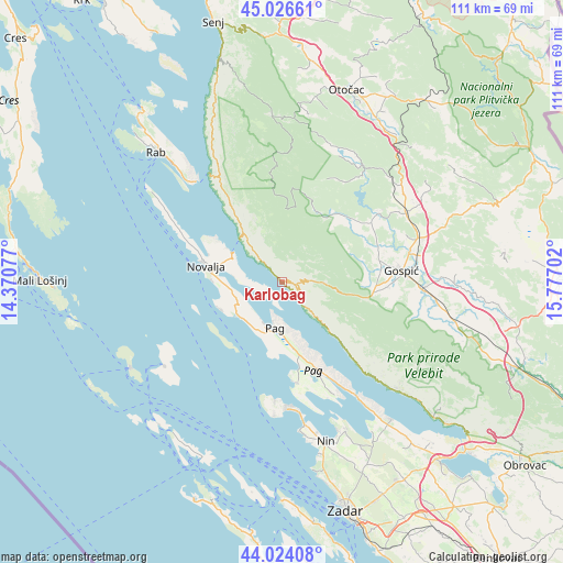
Karlobag GPS coordinates[2]
44° 31' 39" North, 15° 4' 26.004" East
| Map corner | latitude | longitude |
|---|---|---|
| Upper-left | 45.02661°, | 14.37077° |
| Center: | 44.5275°, | 15.07389° |
| Lower-right: | 44.02408°, | 15.77702° |
| Map W x H: | 111.5×111.5 km | = 69.3×69.3mi |
| max Lat: | 46.52694° ⇑79.3% North |
| Karlobag: | 44.5275° |
| min Lat: | ⇓20.7% South 42.54972° |
| min Long | Karlobag | max Long |
| 13.52389° | 15.07389° | 19.37694° |
| W 11.2%⇐ | ⇒88.8% E |
Elevation
Elevation of Karlobag is 30 m = 98 ft, and this is 123.3 m = 405 ft below average elevation for this country.
| Max E: |
827 m = 2713 ft | 88.4% |
| Avg. | 153.3 m = 503 ft | |
| Karlobag | 30 m = 98 ft | |
Min E: |
-1 m = -3 ft | 11.6% |
See also: Croatia elevation on elevation.city.
Geographical zone
Karlobag is located in North temperate zone (between Tropic of Cancer and the Arctic Circle). Distance of this Northern Tropic circle is 2345.1 km =1457.2 mi to South.| Distance of | km | miles | from Karlobag |
|---|---|---|---|
| North Pole | 5056.1 | 3141.7 | to North |
| Arctic Circle | 2450.2 | 1522.5 | to North |
| Tropic Cancer | 2345.1 | 1457.2 | to South |
| Equator | 4951 | 3076.4 | to South |


Nearby cities:
15 places around Karlobag: (largest is in red/bold)
• Banjol
33.8 km =21 mi,  317°
317°
• Gospić
23.9 km =14.9 mi,  85°
85°
• Kolan
9.7 km =6 mi,  247°
247°
• Kuterevo
33.5 km =20.8 mi,  9°
9°
• Lički Osik
29.1 km =18.1 mi,  73°
73°
• Nin
32.9 km =20.4 mi,  165°
165°
• Novalja
15.2 km =9.4 mi,  282°
282°
• Pag
9.3 km =5.8 mi,  188°
188°
• Perušić
28 km =17.4 mi,  61°
61°
• Popovača
15 km =9.3 mi,  33°
33°
• Povljana
20.4 km =12.7 mi, 170°
• Privlaka
29.4 km =18.3 mi, 170°
• Stari Grad
10.9 km =6.8 mi,  184°
184°
• Vir
25 km =15.5 mi, 177°
• Vrsi
31.8 km =19.8 mi,  156°
156°
Sources, notices
• [Note1] Compared only with cities in Croatia existing in our database
• [Src1] Map data: © OpenStreetMap contributors (CC-BY-SA)
• [Src2] Other city data from geonames.org with taken over terms of usage.
• [Src3] Geographical zone / Annual Mean Temperature by Robert A. Rohde @ Wikipedia
