Motovun geodata
Motovun (Istria) is a seat of a second-order administrative division; located in Croatia in Europe/Zagreb (GMT+2) time zone. With population of 531 people, there are 843 cities with bigger population in this country. Compared to other cities in Croatia, 57% of cities are located further ↑North; 98.1% of cities are located further →East and 88.1% of cities have lower elevation than Motovun. Note1


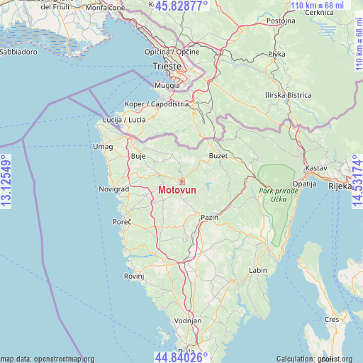
Motovun GPS coordinates[2]
45° 20' 12.012" North, 13° 49' 42.996" East
| Map corner | latitude | longitude |
|---|---|---|
| Upper-left | 45.82877°, | 13.12549° |
| Center: | 45.33667°, | 13.82861° |
| Lower-right: | 44.84026°, | 14.53174° |
| Map W x H: | 109.9×109.9 km | = 68.3×68.3mi |
| max Lat: | 46.52694° ⇑57% North |
| Motovun: | 45.33667° |
| min Lat: | ⇓43% South 42.54972° |
| min Long | Motovun | max Long |
| 13.52389° | 13.82861° | 19.37694° |
| W 1.9%⇐ | ⇒98.1% E |
Elevation
Elevation of Motovun is 270 m = 886 ft, and this is 116.7 m = 383 ft above average elevation for this country.
| Max E: |
827 m = 2713 ft | 11.9% |
| Motovun | 270 m 886 ft | |
| Avg. | 153.3 m = 503 ft | |
Min E: |
-1 m = -3 ft | 88.1% |
See also: Croatia elevation on elevation.city.
Geographical zone
Motovun is located in North temperate zone (between Tropic of Cancer and the Arctic Circle). Distance of this North polar circle is 2360.2 km =1466.6 mi to North.| Distance of | km | miles | from Motovun |
|---|---|---|---|
| North Pole | 4966.1 | 3085.8 | to North |
| Arctic Circle | 2360.2 | 1466.6 | to North |
| Tropic Cancer | 2435 | 1513 | to South |
| Equator | 5041 | 3132.3 | to South |


Nearby cities:
15 places around Motovun: (largest is in red/bold)
• Brtonigla
16.3 km =10.1 mi,  287°
287°
• Buje
15.4 km =9.6 mi,  302°
302°
• Buzet
13.5 km =8.4 mi,  53°
53°
• Cerovlje
15.8 km =9.8 mi,  114°
114°
• Grožnjan
9.4 km =5.8 mi, 299°
• Karojba
4 km =2.5 mi,  186°
186°
• Kaštelir
11.8 km =7.3 mi,  251°
251°
• Oprtalj
5 km =3.1 mi,  357°
357°
• Pazin
13.6 km =8.5 mi,  141°
141°
• Sveti Lovreč Pazenatički
19.1 km =11.9 mi,  200°
200°
• Sveti Petar u Šumi
17.3 km =10.7 mi,  169°
169°
• Tar
16.4 km =10.2 mi,  255°
255°
• Tinjan
13.2 km =8.2 mi,  176°
176°
• Visignano
10.8 km =6.7 mi,  231°
231°
• Vižinada
5.5 km =3.4 mi, 261°
Sources, notices
• [Note1] Compared only with cities in Croatia existing in our database
• [Src1] Map data: © OpenStreetMap contributors (CC-BY-SA)
• [Src2] Other city data from geonames.org with taken over terms of usage.
• [Src3] Geographical zone / Annual Mean Temperature by Robert A. Rohde @ Wikipedia
