Cerovlje geodata
Cerovlje (Istria) is a seat of a second-order administrative division; located in Croatia in Europe/Zagreb (GMT+2) time zone. In our database, there are 904 cities with bigger population. Compared to other cities in Croatia, 61.4% of cities are located further ↑North; 96.4% of cities are located further →East and 89.7% of cities have lower elevation than Cerovlje. Note1


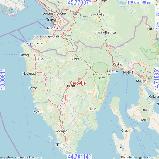
Cerovlje GPS coordinates[2]
45° 16' 41.016" North, 14° 0' 43.992" East
| Map corner | latitude | longitude |
|---|---|---|
| Upper-left | 45.77067°, | 13.3091° |
| Center: | 45.27806°, | 14.01222° |
| Lower-right: | 44.78114°, | 14.71535° |
| Map W x H: | 110×110 km | = 68.4×68.4mi |
| max Lat: | 46.52694° ⇑61.4% North |
| Cerovlje: | 45.27806° |
| min Lat: | ⇓38.6% South 42.54972° |
| min Long | Cerovlje | max Long |
| 13.52389° | 14.01222° | 19.37694° |
| W 3.6%⇐ | ⇒96.4% E |
Elevation
Elevation of Cerovlje is 294 m = 965 ft, and this is 140.7 m = 462 ft above average elevation for this country.
| Max E: |
827 m = 2713 ft | 10.3% |
| Cerovlje | 294 m 965 ft | |
| Avg. | 153.3 m = 503 ft | |
Min E: |
-1 m = -3 ft | 89.7% |
See also: Croatia elevation on elevation.city.
Geographical zone
Cerovlje is located in North temperate zone (between Tropic of Cancer and the Arctic Circle). Distance of this North polar circle is 2366.7 km =1470.6 mi to North.| Distance of | km | miles | from Cerovlje |
|---|---|---|---|
| North Pole | 4972.6 | 3089.8 | to North |
| Arctic Circle | 2366.7 | 1470.6 | to North |
| Tropic Cancer | 2428.5 | 1509 | to South |
| Equator | 5034.4 | 3128.2 | to South |


Nearby cities:
15 places around Cerovlje: (largest is in red/bold)
• Buzet
15 km =9.3 mi,  346°
346°
• Gorica
15.2 km =9.4 mi,  179°
179°
• Gračišće
6.6 km =4.1 mi, 181°
• Karojba
15 km =9.3 mi,  279°
279°
• Kršan
15.3 km =9.5 mi,  139°
139°
• Lanišće
16.5 km =10.3 mi,  29°
29°
• Motovun
15.8 km =9.8 mi,  294°
294°
• Nedeščina
17.2 km =10.7 mi,  153°
153°
• Oprtalj
18.6 km =11.6 mi,  308°
308°
• Pazin
7.3 km =4.5 mi,  234°
234°
• Pićan
8.4 km =5.2 mi,  163°
163°
• Potpićan
12 km =7.5 mi, 145°
• Sveti Petar u Šumi
15.4 km =9.6 mi, 227°
• Tinjan
15.1 km =9.4 mi,  243°
243°
• Žminj
17.1 km =10.6 mi,  208°
208°
Sources, notices
• [Note1] Compared only with cities in Croatia existing in our database
• [Src1] Map data: © OpenStreetMap contributors (CC-BY-SA)
• [Src2] Other city data from geonames.org with taken over terms of usage.
• [Src3] Geographical zone / Annual Mean Temperature by Robert A. Rohde @ Wikipedia
