Kopačevo geodata
Kopačevo (Osječko-Baranjska) is a populated place; located in Croatia in Europe/Zagreb (GMT+2) time zone. With population of 559 people, there are 800 cities with bigger population in this country. Compared to other cities in Croatia, 58.9% of cities are located further ↓South; 95.8% of cities are located further ←West and 83% of cities have higher elevation than Kopačevo. Note1


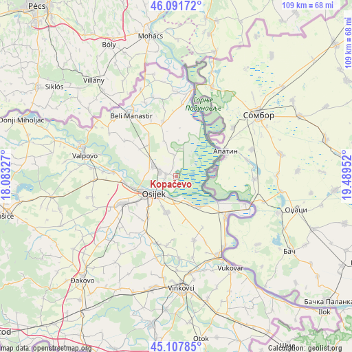
Kopačevo GPS coordinates[2]
45° 36' 6.984" North, 18° 47' 11.004" East
| Map corner | latitude | longitude |
|---|---|---|
| Upper-left | 46.09172°, | 18.08327° |
| Center: | 45.60194°, | 18.78639° |
| Lower-right: | 45.10785°, | 19.48952° |
| Map W x H: | 109.4×109.4 km | = 68×68mi |
| max Lat: | 46.52694° ⇑41.1% North |
| Kopačevo: | 45.60194° |
| min Lat: | ⇓58.9% South 42.54972° |
| min Long | Kopačevo | max Long |
| 13.52389° | 18.78639° | 19.37694° |
| W 95.8%⇐ | ⇒4.2% E |
Elevation
Elevation of Kopačevo is 82 m = 269 ft, and this is 71.3 m = 234 ft below average elevation for this country.
| Max E: |
827 m = 2713 ft | 83% |
| Avg. | 153.3 m = 503 ft | |
| Kopačevo | 82 m = 269 ft | |
Min E: |
-1 m = -3 ft | 17% |
See also: Croatia elevation on elevation.city.
Geographical zone
Kopačevo is located in North temperate zone (between Tropic of Cancer and the Arctic Circle). Distance of this North polar circle is 2330.7 km =1448.2 mi to North.| Distance of | km | miles | from Kopačevo |
|---|---|---|---|
| North Pole | 4936.6 | 3067.5 | to North |
| Arctic Circle | 2330.7 | 1448.2 | to North |
| Tropic Cancer | 2464.5 | 1531.4 | to South |
| Equator | 5070.5 | 3150.7 | to South |


Nearby cities:
15 places around Kopačevo: (largest is in red/bold)
• Bijelo Brdo
11.5 km =7.1 mi,  145°
145°
• Bilje
3.4 km =2.1 mi,  279°
279°
• Brijest
12.7 km =7.9 mi,  224°
224°
• Darda
7.3 km =4.5 mi,  293°
293°
• Grabovac
11.2 km =7 mi,  341°
341°
• Lug
6.8 km =4.2 mi,  353°
353°
• Mece
5.5 km =3.4 mi, 290°
• Osijek
9.2 km =5.7 mi,  231°
231°
• Sarvaš
9.2 km =5.7 mi, 154°
• Tenja
11.9 km =7.4 mi,  194°
194°
• Tvrđavica
9.2 km =5.7 mi,  248°
248°
• Uglješ
11.8 km =7.3 mi,  304°
304°
• Vardarac
3.1 km =1.9 mi, 336°
• Višnjevac
13.9 km =8.6 mi, 254°
• Čeminac
13.2 km =8.2 mi,  315°
315°
Sources, notices
• [Note1] Compared only with cities in Croatia existing in our database
• [Src1] Map data: © OpenStreetMap contributors (CC-BY-SA)
• [Src2] Other city data from geonames.org with taken over terms of usage.
• [Src3] Geographical zone / Annual Mean Temperature by Robert A. Rohde @ Wikipedia
