Darda geodata
Darda (Osječko-Baranjska) is a seat of a second-order administrative division; located in Croatia in Europe/Zagreb (GMT+2) time zone. With population of 5,420 people, there are 74 cities with bigger population in this country. Compared to other cities in Croatia, 60.2% of cities are located further ↓South; 94.1% of cities are located further ←West and 79.3% of cities have higher elevation than Darda. Note1


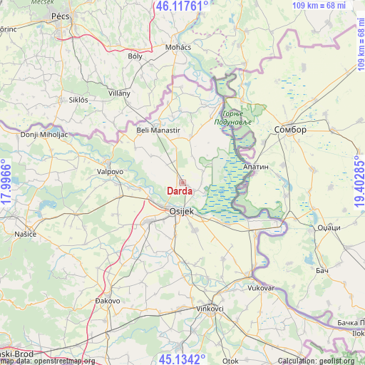
Darda GPS coordinates[2]
45° 37' 41.016" North, 18° 41' 58.992" East
| Map corner | latitude | longitude |
|---|---|---|
| Upper-left | 46.11761°, | 17.9966° |
| Center: | 45.62806°, | 18.69972° |
| Lower-right: | 45.1342°, | 19.40285° |
| Map W x H: | 109.3×109.3 km | = 67.9×67.9mi |
| max Lat: | 46.52694° ⇑39.8% North |
| Darda: | 45.62806° |
| min Lat: | ⇓60.2% South 42.54972° |
| min Long | Darda | max Long |
| 13.52389° | 18.69972° | 19.37694° |
| W 94.1%⇐ | ⇒5.9% E |
Elevation
Elevation of Darda is 86 m = 282 ft, and this is 67.3 m = 221 ft below average elevation for this country.
| Max E: |
827 m = 2713 ft | 79.3% |
| Avg. | 153.3 m = 503 ft | |
| Darda | 86 m = 282 ft | |
Min E: |
-1 m = -3 ft | 20.7% |
See also: Croatia elevation on elevation.city.
Geographical zone
Darda is located in North temperate zone (between Tropic of Cancer and the Arctic Circle). Distance of this North polar circle is 2327.8 km =1446.4 mi to North.| Distance of | km | miles | from Darda |
|---|---|---|---|
| North Pole | 4933.7 | 3065.7 | to North |
| Arctic Circle | 2327.8 | 1446.4 | to North |
| Tropic Cancer | 2467.4 | 1533.2 | to South |
| Equator | 5073.4 | 3152.5 | to South |


Nearby cities:
15 places around Darda: (largest is in red/bold)
• Bilje
4.2 km =2.6 mi,  124°
124°
• Brijest
12.1 km =7.5 mi,  190°
190°
• Grabovac
8.3 km =5.2 mi,  22°
22°
• Jagodnjak
12.4 km =7.7 mi,  309°
309°
• Josipovac
10.5 km =6.5 mi,  241°
241°
• Kopačevo
7.3 km =4.5 mi,  113°
113°
• Kozarac
10.3 km =6.4 mi,  349°
349°
• Lug
7 km =4.3 mi,  57°
57°
• Mece
1.9 km =1.2 mi, 122°
• Osijek
8.6 km =5.3 mi,  183°
183°
• Tvrđavica
6.6 km =4.1 mi,  196°
196°
• Uglješ
4.9 km =3 mi,  322°
322°
• Vardarac
5.5 km =3.4 mi,  90°
90°
• Višnjevac
9.4 km =5.8 mi,  225°
225°
• Čeminac
7 km =4.3 mi,  338°
338°
Sources, notices
• [Note1] Compared only with cities in Croatia existing in our database
• [Src1] Map data: © OpenStreetMap contributors (CC-BY-SA)
• [Src2] Other city data from geonames.org with taken over terms of usage.
• [Src3] Geographical zone / Annual Mean Temperature by Robert A. Rohde @ Wikipedia
