Bale geodata
Bale (Istria) is a seat of a second-order administrative division; located in Croatia in Europe/Zagreb (GMT+2) time zone. With population of 890 people, there are 532 cities with bigger population in this country. Compared to other cities in Croatia, 74.8% of cities are located further ↑North; 98.6% of cities are located further →East and 54.3% of cities have lower elevation than Bale. Note1


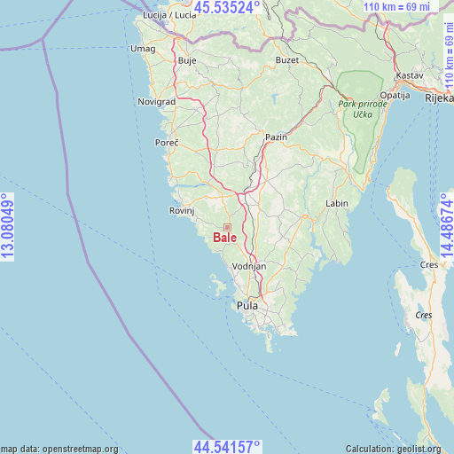
Bale GPS coordinates[2]
45° 2' 26.016" North, 13° 47' 0.996" East
| Map corner | latitude | longitude |
|---|---|---|
| Upper-left | 45.53524°, | 13.08049° |
| Center: | 45.04056°, | 13.78361° |
| Lower-right: | 44.54157°, | 14.48674° |
| Map W x H: | 110.5×110.5 km | = 68.7×68.7mi |
| max Lat: | 46.52694° ⇑74.8% North |
| Bale: | 45.04056° |
| min Lat: | ⇓25.2% South 42.54972° |
| min Long | Bale | max Long |
| 13.52389° | 13.78361° | 19.37694° |
| W 1.4%⇐ | ⇒98.6% E |
Elevation
Elevation of Bale is 134 m = 440 ft, and this is 19.3 m = 63 ft below average elevation for this country.
| Max E: |
827 m = 2713 ft | 45.7% |
| Avg. | 153.3 m = 503 ft | |
| Bale | 134 m = 440 ft | |
Min E: |
-1 m = -3 ft | 54.3% |
See also: Croatia elevation on elevation.city.
Geographical zone
Bale is located in North temperate zone (between Tropic of Cancer and the Arctic Circle). Distance of this North polar circle is 2393.1 km =1487 mi to North.| Distance of | km | miles | from Bale |
|---|---|---|---|
| North Pole | 4999 | 3106.2 | to North |
| Arctic Circle | 2393.1 | 1487 | to North |
| Tropic Cancer | 2402.1 | 1492.6 | to South |
| Equator | 5008 | 3111.8 | to South |


Nearby cities:
15 places around Bale: (largest is in red/bold)
• Barban
18.3 km =11.4 mi,  81°
81°
• Fažana
12.7 km =7.9 mi,  172°
172°
• Galižana
13.8 km =8.6 mi,  151°
151°
• Kanfanar
10 km =6.2 mi,  25°
25°
• Loborika
16.9 km =10.5 mi, 145°
• Marčana
16.4 km =10.2 mi,  125°
125°
• Pula
19.8 km =12.3 mi, 165°
• Rovinj
12.1 km =7.5 mi,  291°
291°
• Sveti Lovreč Pazenatički
15.4 km =9.6 mi,  347°
347°
• Sveti Petar u Šumi
17.2 km =10.7 mi,  22°
22°
• Svetvinčenat
9.5 km =5.9 mi,  56°
56°
• Valbandon
13.7 km =8.5 mi, 170°
• Vodnjan
10.5 km =6.5 mi, 149°
• Vrsar
18.5 km =11.5 mi,  310°
310°
• Žminj
15 km =9.3 mi,  40°
40°
Sources, notices
• [Note1] Compared only with cities in Croatia existing in our database
• [Src1] Map data: © OpenStreetMap contributors (CC-BY-SA)
• [Src2] Other city data from geonames.org with taken over terms of usage.
• [Src3] Geographical zone / Annual Mean Temperature by Robert A. Rohde @ Wikipedia
