Jakovlje geodata
Jakovlje (Zagrebačka) is a seat of a second-order administrative division; located in Croatia in Europe/Zagreb (GMT+2) time zone. With population of 2,635 people, there are 164 cities with bigger population in this country. Compared to other cities in Croatia, 79.6% of cities are located further ↓South; 73.3% of cities are located further →East and 70% of cities have lower elevation than Jakovlje. Note1


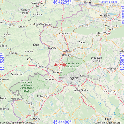
Jakovlje GPS coordinates[2]
45° 56' 9.996" North, 15° 51' 20.124" East
| Map corner | latitude | longitude |
|---|---|---|
| Upper-left | 46.42295°, | 15.15247° |
| Center: | 45.93611°, | 15.85559° |
| Lower-right: | 45.44496°, | 16.55872° |
| Map W x H: | 108.7×108.7 km | = 67.5×67.5mi |
| max Lat: | 46.52694° ⇑20.4% North |
| Jakovlje: | 45.93611° |
| min Lat: | ⇓79.6% South 42.54972° |
| min Long | Jakovlje | max Long |
| 13.52389° | 15.85559° | 19.37694° |
| W 26.7%⇐ | ⇒73.3% E |
Elevation
Elevation of Jakovlje is 167 m = 548 ft, and this is 13.7 m = 45 ft above average elevation for this country.
| Max E: |
827 m = 2713 ft | 30% |
| Jakovlje | 167 m 548 ft | |
| Avg. | 153.3 m = 503 ft | |
Min E: |
-1 m = -3 ft | 70% |
See also: Croatia elevation on elevation.city.
Geographical zone
Jakovlje is located in North temperate zone (between Tropic of Cancer and the Arctic Circle). Distance of this North polar circle is 2293.6 km =1425.2 mi to North.| Distance of | km | miles | from Jakovlje |
|---|---|---|---|
| North Pole | 4899.4 | 3044.3 | to North |
| Arctic Circle | 2293.6 | 1425.2 | to North |
| Tropic Cancer | 2501.7 | 1554.5 | to South |
| Equator | 5107.6 | 3173.7 | to South |


Nearby cities:
15 places around Jakovlje: (largest is in red/bold)
• Donja Bistra
3.2 km =2 mi,  181°
181°
• Donja Pušća
6.4 km =4 mi,  250°
250°
• Gornja Bistra
4.1 km =2.5 mi,  122°
122°
• Gornja Pušća
6.5 km =4 mi,  262°
262°
• Igrišće
3.3 km =2.1 mi,  30°
30°
• Jablanovec
6.7 km =4.2 mi, 181°
• Kupljenovo
3.9 km =2.4 mi, 258°
• Luka
3.7 km =2.3 mi,  311°
311°
• Novaki Bistranski
5.7 km =3.5 mi,  174°
174°
• Oroslavje
8.2 km =5.1 mi, 34°
• Pojatno
5.5 km =3.4 mi,  230°
230°
• Poljanica Bistranska
4.2 km =2.6 mi,  158°
158°
• Stubička Slatina
4.7 km =2.9 mi,  16°
16°
• Stubičke Toplice
7.4 km =4.6 mi,  53°
53°
• Veliko Trgovišće
7.1 km =4.4 mi,  356°
356°
Sources, notices
• [Note1] Compared only with cities in Croatia existing in our database
• [Src1] Map data: © OpenStreetMap contributors (CC-BY-SA)
• [Src2] Other city data from geonames.org with taken over terms of usage.
• [Src3] Geographical zone / Annual Mean Temperature by Robert A. Rohde @ Wikipedia
