Igrišće geodata
Igrišće (Zagrebačka) is a populated place; located in Croatia in Europe/Zagreb (GMT+2) time zone. With population of 731 people, there are 640 cities with bigger population in this country. Compared to other cities in Croatia, 80.2% of cities are located further ↓South; 72.3% of cities are located further →East and 79.2% of cities have lower elevation than Igrišće. Note1


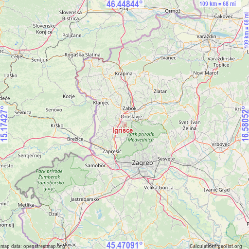
Igrišće GPS coordinates[2]
45° 57' 42.588" North, 15° 52' 38.604" East
| Map corner | latitude | longitude |
|---|---|---|
| Upper-left | 46.44844°, | 15.17427° |
| Center: | 45.96183°, | 15.87739° |
| Lower-right: | 45.47091°, | 16.58052° |
| Map W x H: | 108.7×108.7 km | = 67.5×67.5mi |
| max Lat: | 46.52694° ⇑19.8% North |
| Igrišće: | 45.96183° |
| min Lat: | ⇓80.2% South 42.54972° |
| min Long | Igrišće | max Long |
| 13.52389° | 15.87739° | 19.37694° |
| W 27.7%⇐ | ⇒72.3% E |
Elevation
Elevation of Igrišće is 198 m = 650 ft, and this is 44.7 m = 147 ft above average elevation for this country.
| Max E: |
827 m = 2713 ft | 20.8% |
| Igrišće | 198 m 650 ft | |
| Avg. | 153.3 m = 503 ft | |
Min E: |
-1 m = -3 ft | 79.2% |
See also: Croatia elevation on elevation.city.
Geographical zone
Igrišće is located in North temperate zone (between Tropic of Cancer and the Arctic Circle). Distance of this North polar circle is 2290.7 km =1423.4 mi to North.| Distance of | km | miles | from Igrišće |
|---|---|---|---|
| North Pole | 4896.6 | 3042.6 | to North |
| Arctic Circle | 2290.7 | 1423.4 | to North |
| Tropic Cancer | 2504.6 | 1556.3 | to South |
| Equator | 5110.5 | 3175.5 | to South |


Nearby cities:
15 places around Igrišće: (largest is in red/bold)
• Andraševec
5.9 km =3.7 mi,  60°
60°
• Donja Bistra
6.3 km =3.9 mi,  196°
196°
• Donja Stubica
7.3 km =4.5 mi,  70°
70°
• Gornja Bistra
5.3 km =3.3 mi,  160°
160°
• Jakovlje
3.3 km =2.1 mi,  210°
210°
• Kupljenovo
6.6 km =4.1 mi,  236°
236°
• Luka
4.5 km =2.8 mi,  264°
264°
• Novaki Bistranski
8.6 km =5.3 mi,  187°
187°
• Oroslavje
4.9 km =3 mi,  36°
36°
• Poljanica Bistranska
6.8 km =4.2 mi,  181°
181°
• Pustodol
6.5 km =4 mi,  82°
82°
• Stubička Slatina
1.7 km =1.1 mi,  348°
348°
• Stubičke Toplice
4.5 km =2.8 mi, 69°
• Veliko Trgovišće
4.7 km =2.9 mi,  333°
333°
• Zabok
8.1 km =5 mi,  21°
21°
Sources, notices
• [Note1] Compared only with cities in Croatia existing in our database
• [Src1] Map data: © OpenStreetMap contributors (CC-BY-SA)
• [Src2] Other city data from geonames.org with taken over terms of usage.
• [Src3] Geographical zone / Annual Mean Temperature by Robert A. Rohde @ Wikipedia
