Kupljenovo geodata
Kupljenovo (Zagrebačka) is a populated place; located in Croatia in Europe/Zagreb (GMT+2) time zone. With population of 704 people, there are 665 cities with bigger population in this country. Compared to other cities in Croatia, 79.1% of cities are located further ↓South; 75.2% of cities are located further →East and 59.8% of cities have lower elevation than Kupljenovo. Note1


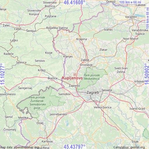
Kupljenovo GPS coordinates[2]
45° 55' 45.048" North, 15° 48' 21.204" East
| Map corner | latitude | longitude |
|---|---|---|
| Upper-left | 46.41608°, | 15.10277° |
| Center: | 45.92918°, | 15.80589° |
| Lower-right: | 45.43797°, | 16.50902° |
| Map W x H: | 108.8×108.8 km | = 67.6×67.6mi |
| max Lat: | 46.52694° ⇑20.9% North |
| Kupljenovo: | 45.92918° |
| min Lat: | ⇓79.1% South 42.54972° |
| min Long | Kupljenovo | max Long |
| 13.52389° | 15.80589° | 19.37694° |
| W 24.8%⇐ | ⇒75.2% E |
Elevation
Elevation of Kupljenovo is 144 m = 472 ft, and this is 9.3 m = 31 ft below average elevation for this country.
| Max E: |
827 m = 2713 ft | 40.2% |
| Avg. | 153.3 m = 503 ft | |
| Kupljenovo | 144 m = 472 ft | |
Min E: |
-1 m = -3 ft | 59.8% |
See also: Croatia elevation on elevation.city.
Geographical zone
Kupljenovo is located in North temperate zone (between Tropic of Cancer and the Arctic Circle). Distance of this North polar circle is 2294.3 km =1425.6 mi to North.| Distance of | km | miles | from Kupljenovo |
|---|---|---|---|
| North Pole | 4900.2 | 3044.8 | to North |
| Arctic Circle | 2294.3 | 1425.6 | to North |
| Tropic Cancer | 2500.9 | 1554 | to South |
| Equator | 5106.8 | 3173.2 | to South |


Nearby cities:
15 places around Kupljenovo: (largest is in red/bold)
• Donja Bistra
4.4 km =2.7 mi,  122°
122°
• Donja Pušća
2.6 km =1.6 mi,  237°
237°
• Dubravica
6.1 km =3.8 mi,  292°
292°
• Gornja Bistra
7.4 km =4.6 mi,  100°
100°
• Gornja Pušća
2.6 km =1.6 mi,  268°
268°
• Igrišće
6.6 km =4.1 mi,  56°
56°
• Jablanovec
7 km =4.3 mi,  148°
148°
• Jakovlje
3.9 km =2.4 mi,  78°
78°
• Luka
3.4 km =2.1 mi,  18°
18°
• Marija Gorica
6.4 km =4 mi,  251°
251°
• Novaki Bistranski
6.6 km =4.1 mi,  138°
138°
• Pojatno
2.7 km =1.7 mi,  188°
188°
• Poljanica Bistranska
6.3 km =3.9 mi, 120°
• Radakovo
7.4 km =4.6 mi,  337°
337°
• Stubička Slatina
7.4 km =4.6 mi,  44°
44°
Sources, notices
• [Note1] Compared only with cities in Croatia existing in our database
• [Src1] Map data: © OpenStreetMap contributors (CC-BY-SA)
• [Src2] Other city data from geonames.org with taken over terms of usage.
• [Src3] Geographical zone / Annual Mean Temperature by Robert A. Rohde @ Wikipedia
