Jagodnjak geodata
Jagodnjak (Osječko-Baranjska) is a seat of a second-order administrative division; located in Croatia in Europe/Zagreb (GMT+2) time zone. With population of 1,476 people, there are 306 cities with bigger population in this country. Compared to other cities in Croatia, 64.6% of cities are located further ↓South; 91.4% of cities are located further ←West and 76.5% of cities have higher elevation than Jagodnjak. Note1


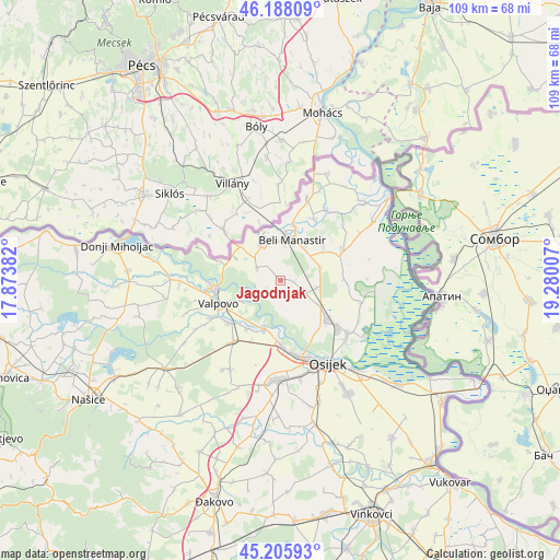
Jagodnjak GPS coordinates[2]
45° 41' 57.012" North, 18° 34' 36.984" East
| Map corner | latitude | longitude |
|---|---|---|
| Upper-left | 46.18809°, | 17.87382° |
| Center: | 45.69917°, | 18.57694° |
| Lower-right: | 45.20593°, | 19.28007° |
| Map W x H: | 109.2×109.2 km | = 67.9×67.9mi |
| max Lat: | 46.52694° ⇑35.4% North |
| Jagodnjak: | 45.69917° |
| min Lat: | ⇓64.6% South 42.54972° |
| min Long | Jagodnjak | max Long |
| 13.52389° | 18.57694° | 19.37694° |
| W 91.4%⇐ | ⇒8.6% E |
Elevation
Elevation of Jagodnjak is 88 m = 289 ft, and this is 65.3 m = 214 ft below average elevation for this country.
| Max E: |
827 m = 2713 ft | 76.5% |
| Avg. | 153.3 m = 503 ft | |
| Jagodnjak | 88 m = 289 ft | |
Min E: |
-1 m = -3 ft | 23.5% |
See also: Croatia elevation on elevation.city.
Geographical zone
Jagodnjak is located in North temperate zone (between Tropic of Cancer and the Arctic Circle). Distance of this North polar circle is 2319.9 km =1441.5 mi to North.| Distance of | km | miles | from Jagodnjak |
|---|---|---|---|
| North Pole | 4925.8 | 3060.7 | to North |
| Arctic Circle | 2319.9 | 1441.5 | to North |
| Tropic Cancer | 2475.4 | 1538.1 | to South |
| Equator | 5081.3 | 3157.4 | to South |


Nearby cities:
15 places around Jagodnjak: (largest is in red/bold)
• Baranjsko Petrovo Selo
10.4 km =6.5 mi,  307°
307°
• Beli Manastir
8.1 km =5 mi,  14°
14°
• Bolman
5.3 km =3.3 mi,  297°
297°
• Branjin Vrh
11.1 km =6.9 mi, 13°
• Darda
12.4 km =7.7 mi,  129°
129°
• Grabovac
12.7 km =7.9 mi,  90°
90°
• Karanac
10.8 km =6.7 mi,  50°
50°
• Kozarac
8 km =5 mi,  73°
73°
• Nard
8.2 km =5.1 mi,  240°
240°
• Petlovac
7.6 km =4.7 mi,  330°
330°
• Petrijevci
10.1 km =6.3 mi,  198°
198°
• Samatovci
12.8 km =8 mi,  206°
206°
• Satnica
11.6 km =7.2 mi,  215°
215°
• Uglješ
7.7 km =4.8 mi,  121°
121°
• Čeminac
7.2 km =4.5 mi,  101°
101°
Sources, notices
• [Note1] Compared only with cities in Croatia existing in our database
• [Src1] Map data: © OpenStreetMap contributors (CC-BY-SA)
• [Src2] Other city data from geonames.org with taken over terms of usage.
• [Src3] Geographical zone / Annual Mean Temperature by Robert A. Rohde @ Wikipedia
