Beli Manastir geodata
Beli Manastir (Osječko-Baranjska) is a seat of a second-order administrative division; located in Croatia in Europe/Zagreb (GMT+2) time zone. With population of 8,713 people, there are 46 cities with bigger population in this country. Compared to other cities in Croatia, 70% of cities are located further ↓South; 91.9% of cities are located further ←West and 70.1% of cities have higher elevation than Beli Manastir. Note1


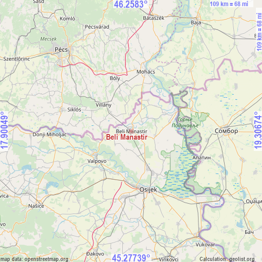
Beli Manastir GPS coordinates[2]
45° 46' 12" North, 18° 36' 12.996" East
| Map corner | latitude | longitude |
|---|---|---|
| Upper-left | 46.2583°, | 17.90049° |
| Center: | 45.77°, | 18.60361° |
| Lower-right: | 45.27739°, | 19.30674° |
| Map W x H: | 109.1×109.1 km | = 67.8×67.8mi |
| max Lat: | 46.52694° ⇑30% North |
| Beli Manastir: | 45.77° |
| min Lat: | ⇓70% South 42.54972° |
| min Long | Beli Manastir | max Long |
| 13.52389° | 18.60361° | 19.37694° |
| W 91.9%⇐ | ⇒8.1% E |
Elevation
Elevation of Beli Manastir is 94 m = 308 ft, and this is 59.3 m = 195 ft below average elevation for this country.
| Max E: |
827 m = 2713 ft | 70.1% |
| Avg. | 153.3 m = 503 ft | |
| Beli Manastir | 94 m = 308 ft | |
Min E: |
-1 m = -3 ft | 29.9% |
See also: Croatia elevation on elevation.city.
Geographical zone
Beli Manastir is located in North temperate zone (between Tropic of Cancer and the Arctic Circle). Distance of this North polar circle is 2312 km =1436.6 mi to North.| Distance of | km | miles | from Beli Manastir |
|---|---|---|---|
| North Pole | 4917.9 | 3055.8 | to North |
| Arctic Circle | 2312 | 1436.6 | to North |
| Tropic Cancer | 2483.2 | 1543 | to South |
| Equator | 5089.1 | 3162.2 | to South |


Nearby cities:
15 places around Beli Manastir: (largest is in red/bold)
• Baranjsko Petrovo Selo
10.5 km =6.5 mi,  261°
261°
• Bolman
8.6 km =5.3 mi,  231°
231°
• Branjin Vrh
2.9 km =1.8 mi,  9°
9°
• Duboševica
15.1 km =9.4 mi,  28°
28°
• Grabovac
13.3 km =8.3 mi,  127°
127°
• Jagodnjak
8.1 km =5 mi,  194°
194°
• Karanac
6.4 km =4 mi,  99°
99°
• Kneževi Vinogradi
10.3 km =6.4 mi, 102°
• Kneževo
9 km =5.6 mi,  19°
19°
• Kozarac
8 km =5 mi,  135°
135°
• Petlovac
6 km =3.7 mi, 257°
• Popovac
6.1 km =3.8 mi,  44°
44°
• Suza
13.4 km =8.3 mi,  83°
83°
• Uglješ
12.8 km =8 mi,  159°
159°
• Čeminac
10.5 km =6.5 mi,  151°
151°
Sources, notices
• [Note1] Compared only with cities in Croatia existing in our database
• [Src1] Map data: © OpenStreetMap contributors (CC-BY-SA)
• [Src2] Other city data from geonames.org with taken over terms of usage.
• [Src3] Geographical zone / Annual Mean Temperature by Robert A. Rohde @ Wikipedia
