Deanovec geodata
Deanovec (Zagrebačka) is a populated place; located in Croatia in Europe/Zagreb (GMT+2) time zone. With population of 536 people, there are 834 cities with bigger population in this country. Compared to other cities in Croatia, 64.4% of cities are located further ↓South; 51.2% of cities are located further ←West and 62.7% of cities have higher elevation than Deanovec. Note1


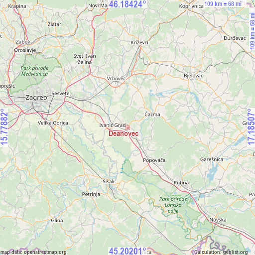
Deanovec GPS coordinates[2]
45° 41' 43.008" North, 16° 28' 54.984" East
| Map corner | latitude | longitude |
|---|---|---|
| Upper-left | 46.18424°, | 15.77882° |
| Center: | 45.69528°, | 16.48194° |
| Lower-right: | 45.20201°, | 17.18507° |
| Map W x H: | 109.2×109.2 km | = 67.9×67.9mi |
| max Lat: | 46.52694° ⇑35.6% North |
| Deanovec: | 45.69528° |
| min Lat: | ⇓64.4% South 42.54972° |
| min Long | Deanovec | max Long |
| 13.52389° | 16.48194° | 19.37694° |
| W 51.2%⇐ | ⇒48.8% E |
Elevation
Elevation of Deanovec is 105 m = 344 ft, and this is 48.3 m = 158 ft below average elevation for this country.
| Max E: |
827 m = 2713 ft | 62.7% |
| Avg. | 153.3 m = 503 ft | |
| Deanovec | 105 m = 344 ft | |
Min E: |
-1 m = -3 ft | 37.3% |
See also: Croatia elevation on elevation.city.
Geographical zone
Deanovec is located in North temperate zone (between Tropic of Cancer and the Arctic Circle). Distance of this North polar circle is 2320.3 km =1441.8 mi to North.| Distance of | km | miles | from Deanovec |
|---|---|---|---|
| North Pole | 4926.2 | 3061 | to North |
| Arctic Circle | 2320.3 | 1441.8 | to North |
| Tropic Cancer | 2474.9 | 1537.8 | to South |
| Equator | 5080.8 | 3157.1 | to South |


Nearby cities:
15 places around Deanovec: (largest is in red/bold)
• Bunjani
1.5 km =0.9 mi,  69°
69°
• Dubrava
16.4 km =10.2 mi,  15°
15°
• Ivanić-Grad
6.8 km =4.2 mi,  282°
282°
• Kloštar Ivanić
6.7 km =4.2 mi,  318°
318°
• Križ
4.7 km =2.9 mi,  136°
136°
• Lupoglav
15.4 km =9.6 mi, 316°
• Martinska Ves
14.9 km =9.3 mi,  213°
213°
• Novoselec
6.4 km =4 mi, 138°
• Obedišće
9 km =5.6 mi, 140°
• Oborovo
17.5 km =10.9 mi,  265°
265°
• Popovača
17.9 km =11.1 mi, 141°
• Posavski Bregi
10.1 km =6.3 mi,  260°
260°
• Velika Ludina
14 km =8.7 mi, 139°
• Vidrenjak
11.8 km =7.3 mi, 142°
• Čazma
11.8 km =7.3 mi,  60°
60°
Sources, notices
• [Note1] Compared only with cities in Croatia existing in our database
• [Src1] Map data: © OpenStreetMap contributors (CC-BY-SA)
• [Src2] Other city data from geonames.org with taken over terms of usage.
• [Src3] Geographical zone / Annual Mean Temperature by Robert A. Rohde @ Wikipedia
