Borovo geodata
Borovo (Vukovar-Sirmium) is a populated place; located in Croatia in Europe/Zagreb (GMT+2) time zone. With population of 5,056 people, there are 78 cities with bigger population in this country. Compared to other cities in Croatia, 53.2% of cities are located further ↑North; 98.6% of cities are located further ←West and 79.3% of cities have higher elevation than Borovo. Note1


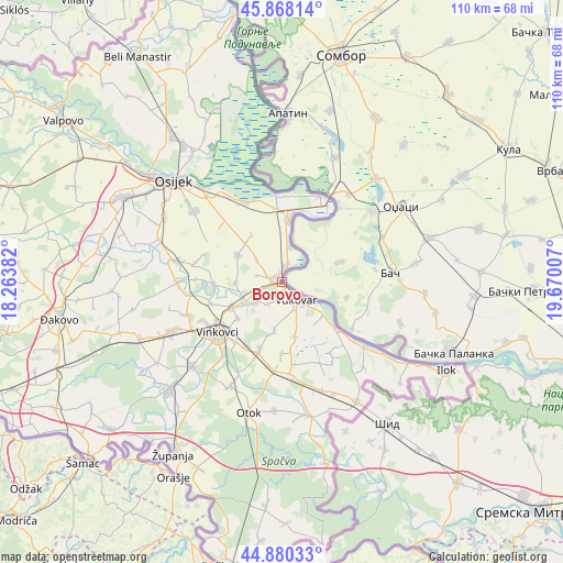
Borovo GPS coordinates[2]
45° 22' 35.004" North, 18° 58' 0.984" East
| Map corner | latitude | longitude |
|---|---|---|
| Upper-left | 45.86814°, | 18.26382° |
| Center: | 45.37639°, | 18.96694° |
| Lower-right: | 44.88033°, | 19.67007° |
| Map W x H: | 109.8×109.8 km | = 68.2×68.2mi |
| max Lat: | 46.52694° ⇑53.2% North |
| Borovo: | 45.37639° |
| min Lat: | ⇓46.8% South 42.54972° |
| min Long | Borovo | max Long |
| 13.52389° | 18.96694° | 19.37694° |
| W 98.6%⇐ | ⇒1.4% E |
Elevation
Elevation of Borovo is 86 m = 282 ft, and this is 67.3 m = 221 ft below average elevation for this country.
| Max E: |
827 m = 2713 ft | 79.3% |
| Avg. | 153.3 m = 503 ft | |
| Borovo | 86 m = 282 ft | |
Min E: |
-1 m = -3 ft | 20.7% |
See also: Croatia elevation on elevation.city.
Geographical zone
Borovo is located in North temperate zone (between Tropic of Cancer and the Arctic Circle). Distance of this North polar circle is 2355.8 km =1463.8 mi to North.| Distance of | km | miles | from Borovo |
|---|---|---|---|
| North Pole | 4961.7 | 3083.1 | to North |
| Arctic Circle | 2355.8 | 1463.8 | to North |
| Tropic Cancer | 2439.5 | 1515.8 | to South |
| Equator | 5045.4 | 3135.1 | to South |


Nearby cities:
15 places around Borovo: (largest is in red/bold)
• Bobota
10.1 km =6.3 mi,  299°
299°
• Bogdanovci
4.9 km =3 mi,  215°
215°
• Borovo Selo
3.3 km =2.1 mi,  12°
12°
• Bršadin
4.6 km =2.9 mi,  250°
250°
• Cerić
11.3 km =7 mi,  230°
230°
• Dalj
12.1 km =7.5 mi, 7°
• Marinci
6.6 km =4.1 mi, 232°
• Negoslavci
11 km =6.8 mi,  167°
167°
• Nuštar
11 km =6.8 mi,  243°
243°
• Pačetin
9.3 km =5.8 mi,  267°
267°
• Petrovcy
9.9 km =6.2 mi,  190°
190°
• Sotin
13.3 km =8.3 mi,  131°
131°
• Stari Jankovci
13.4 km =8.3 mi,  197°
197°
• Trpinja
7.1 km =4.4 mi,  311°
311°
• Vukovar
3.9 km =2.4 mi, 134°
Sources, notices
• [Note1] Compared only with cities in Croatia existing in our database
• [Src1] Map data: © OpenStreetMap contributors (CC-BY-SA)
• [Src2] Other city data from geonames.org with taken over terms of usage.
• [Src3] Geographical zone / Annual Mean Temperature by Robert A. Rohde @ Wikipedia
