Sotin geodata
Sotin (Vukovar-Sirmium) is a populated place; located in Croatia in Europe/Zagreb (GMT+2) time zone. With population of 782 people, there are 615 cities with bigger population in this country. Compared to other cities in Croatia, 60% of cities are located further ↑North; 99.5% of cities are located further ←West and 56.3% of cities have higher elevation than Sotin. Note1


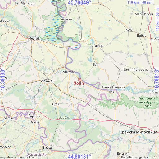
Sotin GPS coordinates[2]
45° 17' 53.016" North, 19° 5' 42" East
| Map corner | latitude | longitude |
|---|---|---|
| Upper-left | 45.79049°, | 18.39188° |
| Center: | 45.29806°, | 19.095° |
| Lower-right: | 44.80131°, | 19.79813° |
| Map W x H: | 110×110 km | = 68.4×68.4mi |
| max Lat: | 46.52694° ⇑60% North |
| Sotin: | 45.29806° |
| min Lat: | ⇓40% South 42.54972° |
| min Long | Sotin | max Long |
| 13.52389° | 19.095° | 19.37694° |
| W 99.5%⇐ | ⇒0.5% E |
Elevation
Elevation of Sotin is 114 m = 374 ft, and this is 39.3 m = 129 ft below average elevation for this country.
| Max E: |
827 m = 2713 ft | 56.3% |
| Avg. | 153.3 m = 503 ft | |
| Sotin | 114 m = 374 ft | |
Min E: |
-1 m = -3 ft | 43.7% |
See also: Croatia elevation on elevation.city.
Geographical zone
Sotin is located in North temperate zone (between Tropic of Cancer and the Arctic Circle). Distance of this North polar circle is 2364.5 km =1469.2 mi to North.| Distance of | km | miles | from Sotin |
|---|---|---|---|
| North Pole | 4970.4 | 3088.5 | to North |
| Arctic Circle | 2364.5 | 1469.2 | to North |
| Tropic Cancer | 2430.8 | 1510.4 | to South |
| Equator | 5036.7 | 3129.7 | to South |


Nearby cities:
15 places around Sotin: (largest is in red/bold)
• Bogdanovci
13.7 km =8.5 mi,  290°
290°
• Borovo
13.3 km =8.3 mi,  311°
311°
• Borovo Selo
15.1 km =9.4 mi,  322°
322°
• Ilača
13 km =8.1 mi,  179°
179°
• Lovas
9.9 km =6.2 mi,  143°
143°
• Marinci
16 km =9.9 mi, 286°
• Negoslavci
8 km =5 mi,  254°
254°
• Orolik
12.6 km =7.8 mi,  223°
223°
• Petrovcy
11.8 km =7.3 mi,  265°
265°
• Slakovci
14 km =8.7 mi,  234°
234°
• Srijemske Laze
14.8 km =9.2 mi,  239°
239°
• Stari Jankovci
14.7 km =9.1 mi, 254°
• Tompojevci
7.2 km =4.5 mi, 181°
• Tovarnik
15.5 km =9.6 mi,  163°
163°
• Vukovar
9.4 km =5.8 mi, 309°
Sources, notices
• [Note1] Compared only with cities in Croatia existing in our database
• [Src1] Map data: © OpenStreetMap contributors (CC-BY-SA)
• [Src2] Other city data from geonames.org with taken over terms of usage.
• [Src3] Geographical zone / Annual Mean Temperature by Robert A. Rohde @ Wikipedia
