Negoslavci geodata
Negoslavci (Vukovar-Sirmium) is a seat of a second-order administrative division; located in Croatia in Europe/Zagreb (GMT+2) time zone. With population of 1,473 people, there are 307 cities with bigger population in this country. Compared to other cities in Croatia, 61.2% of cities are located further ↑North; 99% of cities are located further ←West and 61.8% of cities have higher elevation than Negoslavci. Note1


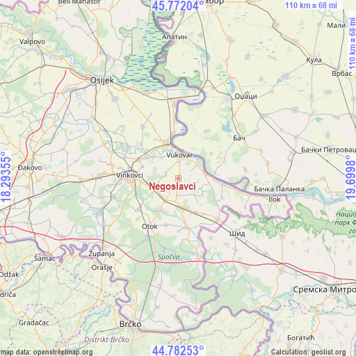
Negoslavci GPS coordinates[2]
45° 16' 45.984" North, 18° 59' 48.012" East
| Map corner | latitude | longitude |
|---|---|---|
| Upper-left | 45.77204°, | 18.29355° |
| Center: | 45.27944°, | 18.99667° |
| Lower-right: | 44.78253°, | 19.6998° |
| Map W x H: | 110×110 km | = 68.4×68.4mi |
| max Lat: | 46.52694° ⇑61.2% North |
| Negoslavci: | 45.27944° |
| min Lat: | ⇓38.8% South 42.54972° |
| min Long | Negoslavci | max Long |
| 13.52389° | 18.99667° | 19.37694° |
| W 99%⇐ | ⇒1% E |
Elevation
Elevation of Negoslavci is 107 m = 351 ft, and this is 46.3 m = 152 ft below average elevation for this country.
| Max E: |
827 m = 2713 ft | 61.8% |
| Avg. | 153.3 m = 503 ft | |
| Negoslavci | 107 m = 351 ft | |
Min E: |
-1 m = -3 ft | 38.2% |
See also: Croatia elevation on elevation.city.
Geographical zone
Negoslavci is located in North temperate zone (between Tropic of Cancer and the Arctic Circle). Distance of this North polar circle is 2366.6 km =1470.5 mi to North.| Distance of | km | miles | from Negoslavci |
|---|---|---|---|
| North Pole | 4972.5 | 3089.8 | to North |
| Arctic Circle | 2366.6 | 1470.5 | to North |
| Tropic Cancer | 2428.7 | 1509.1 | to South |
| Equator | 5034.6 | 3128.4 | to South |


Nearby cities:
15 places around Negoslavci: (largest is in red/bold)
• Bogdanovci
8.5 km =5.3 mi,  322°
322°
• Borovo
11 km =6.8 mi,  347°
347°
• Bršadin
11.4 km =7.1 mi, 324°
• Cerić
11.6 km =7.2 mi,  287°
287°
• Marinci
10.2 km =6.3 mi,  311°
311°
• Mirkovci
11.4 km =7.1 mi,  264°
264°
• Novi Jankovci
9 km =5.6 mi,  240°
240°
• Orolik
7.2 km =4.5 mi,  187°
187°
• Petrovcy
4.2 km =2.6 mi,  284°
284°
• Slakovci
7.1 km =4.4 mi,  210°
210°
• Sotin
8 km =5 mi,  74°
74°
• Srijemske Laze
7.4 km =4.6 mi,  222°
222°
• Stari Jankovci
6.7 km =4.2 mi,  253°
253°
• Tompojevci
9 km =5.6 mi,  124°
124°
• Vukovar
8 km =5 mi,  3°
3°
Sources, notices
• [Note1] Compared only with cities in Croatia existing in our database
• [Src1] Map data: © OpenStreetMap contributors (CC-BY-SA)
• [Src2] Other city data from geonames.org with taken over terms of usage.
• [Src3] Geographical zone / Annual Mean Temperature by Robert A. Rohde @ Wikipedia
