Vukovar geodata
Vukovar (Vukovar-Sirmium) is a seat of a first-order administrative division; located in Croatia in Europe/Zagreb (GMT+2) time zone. With population of 29,584 people, there are 16 cities with bigger population in this country. Compared to other cities in Croatia, 55.6% of cities are located further ↑North; 99.1% of cities are located further ←West and 84.7% of cities have higher elevation than Vukovar. Note1


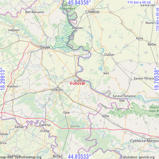
Vukovar GPS coordinates[2]
45° 21' 5.796" North, 19° 0' 8.1" East
| Map corner | latitude | longitude |
|---|---|---|
| Upper-left | 45.84358°, | 18.29913° |
| Center: | 45.35161°, | 19.00225° |
| Lower-right: | 44.85533°, | 19.70538° |
| Map W x H: | 109.9×109.9 km | = 68.3×68.3mi |
| max Lat: | 46.52694° ⇑55.6% North |
| Vukovar: | 45.35161° |
| min Lat: | ⇓44.4% South 42.54972° |
| min Long | Vukovar | max Long |
| 13.52389° | 19.00225° | 19.37694° |
| W 99.1%⇐ | ⇒0.90000000000001% E |
Elevation
Elevation of Vukovar is 70 m = 230 ft, and this is 83.3 m = 273 ft below average elevation for this country.
| Max E: |
827 m = 2713 ft | 84.7% |
| Avg. | 153.3 m = 503 ft | |
| Vukovar | 70 m = 230 ft | |
Min E: |
-1 m = -3 ft | 15.3% |
See also: Croatia elevation on elevation.city.
Geographical zone
Vukovar is located in North temperate zone (between Tropic of Cancer and the Arctic Circle). Distance of this North polar circle is 2358.5 km =1465.5 mi to North.| Distance of | km | miles | from Vukovar |
|---|---|---|---|
| North Pole | 4964.4 | 3084.7 | to North |
| Arctic Circle | 2358.5 | 1465.5 | to North |
| Tropic Cancer | 2436.7 | 1514.1 | to South |
| Equator | 5042.6 | 3133.3 | to South |


Nearby cities:
15 places around Vukovar: (largest is in red/bold)
• Bobota
13.9 km =8.6 mi,  303°
303°
• Bogdanovci
5.7 km =3.5 mi,  257°
257°
• Borovo
3.9 km =2.4 mi,  314°
314°
• Borovo Selo
6.3 km =3.9 mi,  340°
340°
• Bršadin
7.2 km =4.5 mi,  279°
279°
• Cerić
12.3 km =7.6 mi,  248°
248°
• Marinci
8.1 km =5 mi, 260°
• Negoslavci
8 km =5 mi,  183°
183°
• Nuštar
12.7 km =7.9 mi, 260°
• Pačetin
12.3 km =7.6 mi, 280°
• Petrovcy
8.3 km =5.2 mi,  212°
212°
• Sotin
9.4 km =5.8 mi,  129°
129°
• Srijemske Laze
14.5 km =9 mi,  202°
202°
• Stari Jankovci
12.1 km =7.5 mi, 214°
• Trpinja
11 km =6.8 mi, 313°
Sources, notices
• [Note1] Compared only with cities in Croatia existing in our database
• [Src1] Map data: © OpenStreetMap contributors (CC-BY-SA)
• [Src2] Other city data from geonames.org with taken over terms of usage.
• [Src3] Geographical zone / Annual Mean Temperature by Robert A. Rohde @ Wikipedia
