Batina geodata
Batina (Osječko-Baranjska) is a populated place; located in Croatia in Europe/Zagreb (GMT+2) time zone. With population of 879 people, there are 541 cities with bigger population in this country. Compared to other cities in Croatia, 74.1% of cities are located further ↓South; 96.7% of cities are located further ←West and 79.3% of cities have higher elevation than Batina. Note1


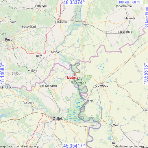
Batina GPS coordinates[2]
45° 50' 45.996" North, 18° 51' 0" East
| Map corner | latitude | longitude |
|---|---|---|
| Upper-left | 46.33374°, | 18.14688° |
| Center: | 45.84611°, | 18.85° |
| Lower-right: | 45.35417°, | 19.55313° |
| Map W x H: | 108.9×108.9 km | = 67.7×67.7mi |
| max Lat: | 46.52694° ⇑25.9% North |
| Batina: | 45.84611° |
| min Lat: | ⇓74.1% South 42.54972° |
| min Long | Batina | max Long |
| 13.52389° | 18.85° | 19.37694° |
| W 96.7%⇐ | ⇒3.3% E |
Elevation
Elevation of Batina is 86 m = 282 ft, and this is 67.3 m = 221 ft below average elevation for this country.
| Max E: |
827 m = 2713 ft | 79.3% |
| Avg. | 153.3 m = 503 ft | |
| Batina | 86 m = 282 ft | |
Min E: |
-1 m = -3 ft | 20.7% |
See also: Croatia elevation on elevation.city.
Geographical zone
Batina is located in North temperate zone (between Tropic of Cancer and the Arctic Circle). Distance of this North polar circle is 2303.6 km =1431.4 mi to North.| Distance of | km | miles | from Batina |
|---|---|---|---|
| North Pole | 4909.5 | 3050.6 | to North |
| Arctic Circle | 2303.6 | 1431.4 | to North |
| Tropic Cancer | 2491.7 | 1548.3 | to South |
| Equator | 5097.6 | 3167.5 | to South |


Nearby cities:
15 places around Batina: (largest is in red/bold)
• Beli Manastir
20.9 km =13 mi,  246°
246°
• Branjin Vrh
19.4 km =12.1 mi, 253°
• Draž
4.8 km =3 mi,  264°
264°
• Duboševica
12.8 km =8 mi,  292°
292°
• Grabovac
18.6 km =11.6 mi,  207°
207°
• Karanac
16 km =9.9 mi,  233°
233°
• Kneževi Vinogradi
14 km =8.7 mi,  220°
220°
• Kneževo
16 km =9.9 mi,  270°
270°
• Kozarac
19.5 km =12.1 mi, 223°
• Lug
21.2 km =13.2 mi,  195°
195°
• Popovac
15.4 km =9.6 mi, 254°
• Suza
9.1 km =5.7 mi, 219°
• Vardarac
25.1 km =15.6 mi,  194°
194°
• Zmajevac
5.9 km =3.7 mi, 212°
• Čeminac
22.7 km =14.1 mi, 218°
Sources, notices
• [Note1] Compared only with cities in Croatia existing in our database
• [Src1] Map data: © OpenStreetMap contributors (CC-BY-SA)
• [Src2] Other city data from geonames.org with taken over terms of usage.
• [Src3] Geographical zone / Annual Mean Temperature by Robert A. Rohde @ Wikipedia
