Katuni geodata
Katuni (Split-Dalmatia) is a populated place; located in Croatia in Europe/Zagreb (GMT+2) time zone. With population of 562 people, there are 795 cities with bigger population in this country. Compared to other cities in Croatia, 92.5% of cities are located further ↑North; 65.6% of cities are located further ←West and 87% of cities have lower elevation than Katuni. Note1


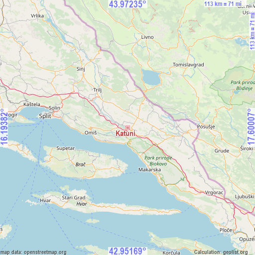
Katuni GPS coordinates[2]
43° 27' 51.012" North, 16° 53' 48.984" East
| Map corner | latitude | longitude |
|---|---|---|
| Upper-left | 43.97235°, | 16.19382° |
| Center: | 43.46417°, | 16.89694° |
| Lower-right: | 42.95169°, | 17.60007° |
| Map W x H: | 113.5×113.5 km | = 70.5×70.5mi |
| max Lat: | 46.52694° ⇑92.5% North |
| Katuni: | 43.46417° |
| min Lat: | ⇓7.5% South 42.54972° |
| min Long | Katuni | max Long |
| 13.52389° | 16.89694° | 19.37694° |
| W 65.6%⇐ | ⇒34.4% E |
Elevation
Elevation of Katuni is 258 m = 846 ft, and this is 104.7 m = 344 ft above average elevation for this country.
| Max E: |
827 m = 2713 ft | 13% |
| Katuni | 258 m 846 ft | |
| Avg. | 153.3 m = 503 ft | |
Min E: |
-1 m = -3 ft | 87% |
See also: Croatia elevation on elevation.city.
Geographical zone
Katuni is located in North temperate zone (between Tropic of Cancer and the Arctic Circle). Distance of this Northern Tropic circle is 2226.8 km =1383.7 mi to South.| Distance of | km | miles | from Katuni |
|---|---|---|---|
| North Pole | 5174.3 | 3215.2 | to North |
| Arctic Circle | 2568.4 | 1595.9 | to North |
| Tropic Cancer | 2226.8 | 1383.7 | to South |
| Equator | 4832.8 | 3003 | to South |


Nearby cities:
15 places around Katuni: (largest is in red/bold)
• Baška Voda
12.7 km =7.9 mi,  160°
160°
• Brela
11 km =6.8 mi, 164°
• Cista Provo
6 km =3.7 mi,  43°
43°
• Duće
18.6 km =11.6 mi,  262°
262°
• Gata
15.9 km =9.9 mi,  271°
271°
• Kostanje
5.8 km =3.6 mi,  243°
243°
• Kučiće
8.5 km =5.3 mi,  246°
246°
• Lokvičič
15.7 km =9.8 mi,  90°
90°
• Lovreć
7.7 km =4.8 mi,  70°
70°
• Omiš
17 km =10.6 mi, 262°
• Pučišća
18.5 km =11.5 mi,  225°
225°
• Stanići
14.7 km =9.1 mi, 247°
• Zadvarje
3.7 km =2.3 mi,  189°
189°
• Zagvozd
14.9 km =9.3 mi,  119°
119°
• Šestanovac
1.6 km =1 mi,  132°
132°
Sources, notices
• [Note1] Compared only with cities in Croatia existing in our database
• [Src1] Map data: © OpenStreetMap contributors (CC-BY-SA)
• [Src2] Other city data from geonames.org with taken over terms of usage.
• [Src3] Geographical zone / Annual Mean Temperature by Robert A. Rohde @ Wikipedia
