Aljmaš geodata
Aljmaš (Osječko-Baranjska) is a populated place; located in Croatia in Europe/Zagreb (GMT+2) time zone. With population of 605 people, there are 747 cities with bigger population in this country. Compared to other cities in Croatia, 55.6% of cities are located further ↓South; 98.4% of cities are located further ←West and 69.7% of cities have higher elevation than Aljmaš. Note1


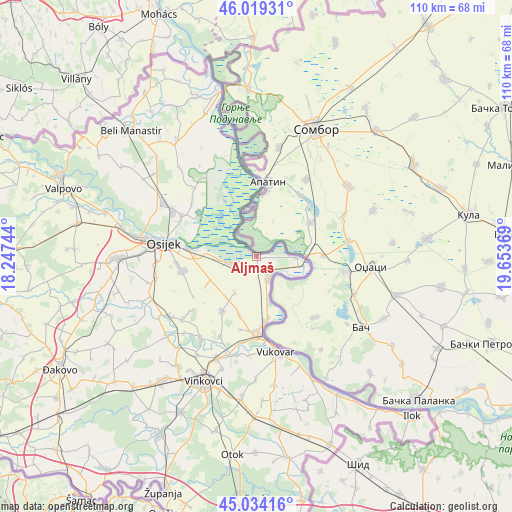
Aljmaš GPS coordinates[2]
45° 31' 44.004" North, 18° 57' 2.016" East
| Map corner | latitude | longitude |
|---|---|---|
| Upper-left | 46.01931°, | 18.24744° |
| Center: | 45.52889°, | 18.95056° |
| Lower-right: | 45.03416°, | 19.65369° |
| Map W x H: | 109.5×109.5 km | = 68×68mi |
| max Lat: | 46.52694° ⇑44.4% North |
| Aljmaš: | 45.52889° |
| min Lat: | ⇓55.6% South 42.54972° |
| min Long | Aljmaš | max Long |
| 13.52389° | 18.95056° | 19.37694° |
| W 98.4%⇐ | ⇒1.6% E |
Elevation
Elevation of Aljmaš is 95 m = 312 ft, and this is 58.3 m = 191 ft below average elevation for this country.
| Max E: |
827 m = 2713 ft | 69.7% |
| Avg. | 153.3 m = 503 ft | |
| Aljmaš | 95 m = 312 ft | |
Min E: |
-1 m = -3 ft | 30.3% |
See also: Croatia elevation on elevation.city.
Geographical zone
Aljmaš is located in North temperate zone (between Tropic of Cancer and the Arctic Circle). Distance of this North polar circle is 2338.8 km =1453.3 mi to North.| Distance of | km | miles | from Aljmaš |
|---|---|---|---|
| North Pole | 4944.7 | 3072.5 | to North |
| Arctic Circle | 2338.8 | 1453.3 | to North |
| Tropic Cancer | 2456.4 | 1526.3 | to South |
| Equator | 5062.3 | 3145.6 | to South |


Nearby cities:
15 places around Aljmaš: (largest is in red/bold)
• Bijelo Brdo
6.3 km =3.9 mi,  258°
258°
• Bilje
18.3 km =11.4 mi,  298°
298°
• Bobota
14.2 km =8.8 mi,  212°
212°
• Borovo
17 km =10.6 mi,  175°
175°
• Borovo Selo
13.9 km =8.6 mi,  171°
171°
• Bršadin
18.7 km =11.6 mi,  189°
189°
• Dalj
5.7 km =3.5 mi,  150°
150°
• Erdut
8.6 km =5.3 mi,  91°
91°
• Kopačevo
15.1 km =9.4 mi, 302°
• Pačetin
19.1 km =11.9 mi,  204°
204°
• Sarvaš
8.8 km =5.5 mi,  268°
268°
• Tenja
16.2 km =10.1 mi, 257°
• Trpinja
12.8 km =8 mi, 198°
• Vardarac
17.8 km =11.1 mi,  308°
308°
• Vukovar
20.1 km =12.5 mi, 168°
Sources, notices
• [Note1] Compared only with cities in Croatia existing in our database
• [Src1] Map data: © OpenStreetMap contributors (CC-BY-SA)
• [Src2] Other city data from geonames.org with taken over terms of usage.
• [Src3] Geographical zone / Annual Mean Temperature by Robert A. Rohde @ Wikipedia
