Matijevići geodata
Matijevići (Sisačko-Moslavačka) is a populated place; located in Croatia in Europe/Zagreb (GMT+2) time zone. With population of 645 people, there are 713 cities with bigger population in this country. Compared to other cities in Croatia, 74.5% of cities are located further ↑North; 54.6% of cities are located further →East and 51.3% of cities have higher elevation than Matijevići. Note1


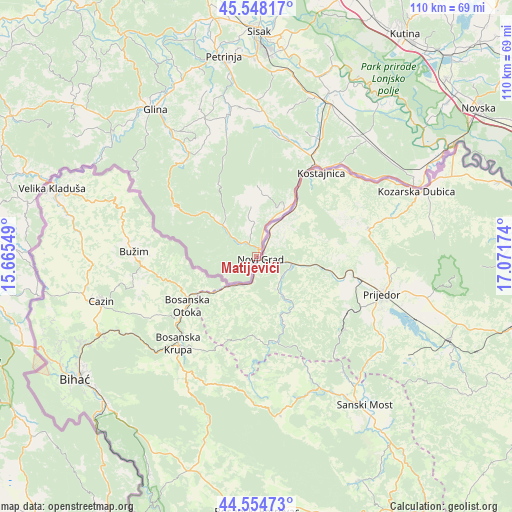
Matijevići GPS coordinates[2]
45° 3' 12.996" North, 16° 22' 6.996" East
| Map corner | latitude | longitude |
|---|---|---|
| Upper-left | 45.54817°, | 15.66549° |
| Center: | 45.05361°, | 16.36861° |
| Lower-right: | 44.55473°, | 17.07174° |
| Map W x H: | 110.5×110.5 km | = 68.7×68.7mi |
| max Lat: | 46.52694° ⇑74.5% North |
| Matijevići: | 45.05361° |
| min Lat: | ⇓25.5% South 42.54972° |
| min Long | Matijevići | max Long |
| 13.52389° | 16.36861° | 19.37694° |
| W 45.4%⇐ | ⇒54.6% E |
Elevation
Elevation of Matijevići is 125 m = 410 ft, and this is 28.3 m = 93 ft below average elevation for this country.
| Max E: |
827 m = 2713 ft | 51.3% |
| Avg. | 153.3 m = 503 ft | |
| Matijevići | 125 m = 410 ft | |
Min E: |
-1 m = -3 ft | 48.7% |
See also: Croatia elevation on elevation.city.
Geographical zone
Matijevići is located in North temperate zone (between Tropic of Cancer and the Arctic Circle). Distance of this North polar circle is 2391.7 km =1486.1 mi to North.| Distance of | km | miles | from Matijevići |
|---|---|---|---|
| North Pole | 4997.6 | 3105.4 | to North |
| Arctic Circle | 2391.7 | 1486.1 | to North |
| Tropic Cancer | 2403.6 | 1493.5 | to South |
| Equator | 5009.5 | 3112.8 | to South |


Nearby cities:
15 places around Matijevići: (largest is in red/bold)
• Budaševo
47.1 km =29.3 mi,  6°
6°
• Donji Kukuruzari
25.3 km =15.7 mi,  20°
20°
• Dvor
2.2 km =1.4 mi,  4°
4°
• Glina
38.5 km =23.9 mi,  325°
325°
• Gornje Komarevo
40.1 km =24.9 mi, 5°
• Hrvatska Dubica
37.2 km =23.1 mi,  65°
65°
• Hrvatska Kostajnica
23.9 km =14.9 mi,  34°
34°
• Jasenovac
49 km =30.4 mi,  60°
60°
• Majur
25.8 km =16 mi, 29°
• Mala Gorica
47.7 km =29.6 mi,  348°
348°
• Petrinja
43.1 km =26.8 mi, 351°
• Sisak
45.9 km =28.5 mi, 0°
• Sunja
38.3 km =23.8 mi, 23°
• Topolovac
45.6 km =28.3 mi, 6°
• Topusko
40.9 km =25.4 mi,  310°
310°
Sources, notices
• [Note1] Compared only with cities in Croatia existing in our database
• [Src1] Map data: © OpenStreetMap contributors (CC-BY-SA)
• [Src2] Other city data from geonames.org with taken over terms of usage.
• [Src3] Geographical zone / Annual Mean Temperature by Robert A. Rohde @ Wikipedia
