Glina geodata
Glina (Sisačko-Moslavačka) is a seat of a second-order administrative division; located in Croatia in Europe/Zagreb (GMT+2) time zone. With population of 3,131 people, there are 131 cities with bigger population in this country. Compared to other cities in Croatia, 56.9% of cities are located further ↑North; 66.2% of cities are located further →East and 58.3% of cities have higher elevation than Glina. Note1


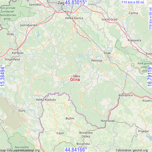
Glina GPS coordinates[2]
45° 20' 17.016" North, 16° 5' 17.016" East
| Map corner | latitude | longitude |
|---|---|---|
| Upper-left | 45.83015°, | 15.38494° |
| Center: | 45.33806°, | 16.08806° |
| Lower-right: | 44.84166°, | 16.79119° |
| Map W x H: | 109.9×109.9 km | = 68.3×68.3mi |
| max Lat: | 46.52694° ⇑56.9% North |
| Glina: | 45.33806° |
| min Lat: | ⇓43.1% South 42.54972° |
| min Long | Glina | max Long |
| 13.52389° | 16.08806° | 19.37694° |
| W 33.8%⇐ | ⇒66.2% E |
Elevation
Elevation of Glina is 112 m = 367 ft, and this is 41.3 m = 135 ft below average elevation for this country.
| Max E: |
827 m = 2713 ft | 58.3% |
| Avg. | 153.3 m = 503 ft | |
| Glina | 112 m = 367 ft | |
Min E: |
-1 m = -3 ft | 41.7% |
See also: Croatia elevation on elevation.city.
Geographical zone
Glina is located in North temperate zone (between Tropic of Cancer and the Arctic Circle). Distance of this North polar circle is 2360.1 km =1466.5 mi to North.| Distance of | km | miles | from Glina |
|---|---|---|---|
| North Pole | 4965.9 | 3085.7 | to North |
| Arctic Circle | 2360.1 | 1466.5 | to North |
| Tropic Cancer | 2435.2 | 1513.2 | to South |
| Equator | 5041.1 | 3132.4 | to South |


Nearby cities:
15 places around Glina: (largest is in red/bold)
• Gornje Komarevo
27.4 km =17 mi,  72°
72°
• Gvozd
17.5 km =10.9 mi,  275°
275°
• Kravarsko
27.4 km =17 mi,  353°
353°
• Lasinja
25.9 km =16.1 mi,  320°
320°
• Lasinja
27.7 km =17.2 mi, 319°
• Lekenik
29.2 km =18.1 mi,  19°
19°
• Mala Gorica
19.4 km =12.1 mi,  38°
38°
• Odra Sisačka
27.2 km =16.9 mi,  48°
48°
• Petrinja
19.3 km =12 mi, 54°
• Pokupsko
18.2 km =11.3 mi,  335°
335°
• Sela
25.4 km =15.8 mi, 41°
• Sisak
26.8 km =16.7 mi,  57°
57°
• Topolovac
30.4 km =18.9 mi, 63°
• Topusko
10.3 km =6.4 mi,  241°
241°
• Žabno
27.2 km =16.9 mi, 48°
Sources, notices
• [Note1] Compared only with cities in Croatia existing in our database
• [Src1] Map data: © OpenStreetMap contributors (CC-BY-SA)
• [Src2] Other city data from geonames.org with taken over terms of usage.
• [Src3] Geographical zone / Annual Mean Temperature by Robert A. Rohde @ Wikipedia
