Saint-Raphaël geodata
Saint-Raphaël (Nord) is a populated place; located in Haiti in America/Port-au-Prince (GMT-4) time zone. With population of 37,739 people, there are 19 cities with bigger population in this country. Compared to other cities in Haiti, 63.2% of cities are located further ↓South; 69.8% of cities are located further ←West and 87.7% of cities have lower elevation than Saint-Raphaël. Note1


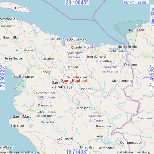
Saint-Raphaël GPS coordinates[2]
19° 26' 19.572" North, 72° 11' 56.76" West
| Map corner | latitude | longitude |
|---|---|---|
| Upper-left | 20.10045°, | -72.90223° |
| Center: | 19.43877°, | -72.1991° |
| Lower-right: | 18.77438°, | -71.49598° |
| Map W x H: | 147.4×147.4 km | = 91.6×91.6mi |
| max Lat: | 19.93984° ⇑36.8% North |
| Saint-Raphaël: | 19.43877° |
| min Lat: | ⇓63.2% South 18.05° |
| min Long | Saint-Raphaël | max Long |
| -74.4528° | -72.1991° | -71.72475° |
| W 69.8%⇐ | ⇒30.2% E |
Elevation
Elevation of Saint-Raphaël is 377 m = 1237 ft, and this is 231.9 m = 761 ft above average elevation for this country.
| Max E: |
1466 m = 4810 ft | 12.3% |
| Saint-Raphaël | 377 m 1237 ft | |
| Avg. | 145.1 m = 476 ft | |
Min E: |
3 m = 10 ft | 87.7% |
See also: Haiti elevation on elevation.city.
Geographical zone
Saint-Raphaël is located in North Torrid zone (between Equator and Tropic of Cancer). Distance of this Northern Tropic circle is 444.5 km =276.2 mi to North.| Distance of | km | miles | from Saint-Raphaël |
|---|---|---|---|
| North Pole | 7845.7 | 4875.1 | to North |
| Arctic Circle | 5239.8 | 3255.9 | to North |
| Tropic Cancer | 444.5 | 276.2 | to North |
| Equator | 2161.4 | 1343 | to South |


Nearby cities:
15 places around Saint-Raphaël: (largest is in red/bold)
• Acul du Nord
29.7 km =18.5 mi,  334°
334°
• Bahon
9.5 km =5.9 mi,  68°
68°
• Dondon
10.9 km =6.8 mi, 334°
• Ennery
30.4 km =18.9 mi,  279°
279°
• Grande Rivière du Nord
15.7 km =9.8 mi,  11°
11°
• Limonade
26.9 km =16.7 mi,  16°
16°
• Marmelade
19.1 km =11.9 mi,  297°
297°
• Mayisad
29.9 km =18.6 mi,  167°
167°
• Milot
18.9 km =11.7 mi,  355°
355°
• Perches
30.4 km =18.9 mi, 72°
• Pignon
14.3 km =8.9 mi,  142°
142°
• Plaine du Nord
27.5 km =17.1 mi,  344°
344°
• Quartier Morin
29 km =18 mi, 8°
• Ranquitte
12.7 km =7.9 mi,  102°
102°
• Trou du Nord
27 km =16.8 mi,  42°
42°
Sources, notices
• [Note1] Compared only with cities in Haiti existing in our database
• [Src1] Map data: © OpenStreetMap contributors (CC-BY-SA)
• [Src2] Other city data from geonames.org with taken over terms of usage.
• [Src3] Geographical zone / Annual Mean Temperature by Robert A. Rohde @ Wikipedia
