Acul du Nord geodata
Acul du Nord (Nord) is a populated place; located in Haiti in America/Port-au-Prince (GMT-4) time zone. With population of 3,454 people, there are 57 cities with bigger population in this country. Compared to other cities in Haiti, 86.8% of cities are located further ↓South; 62.3% of cities are located further ←West and 59.4% of cities have lower elevation than Acul du Nord. Note1


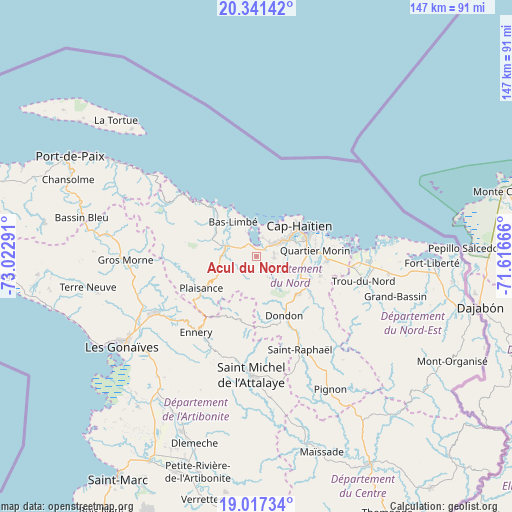
Acul du Nord GPS coordinates[2]
19° 40' 50.7" North, 72° 19' 11.208" West
| Map corner | latitude | longitude |
|---|---|---|
| Upper-left | 20.34142°, | -73.02291° |
| Center: | 19.68075°, | -72.31978° |
| Lower-right: | 19.01734°, | -71.61666° |
| Map W x H: | 147.2×147.2 km | = 91.5×91.5mi |
| max Lat: | 19.93984° ⇑13.2% North |
| Acul du Nord: | 19.68075° |
| min Lat: | ⇓86.8% South 18.05° |
| min Long | Acul du Nord | max Long |
| -74.4528° | -72.31978° | -71.72475° |
| W 62.3%⇐ | ⇒37.7% E |
Elevation
Elevation of Acul du Nord is 61 m = 200 ft, and this is 84.1 m = 276 ft below average elevation for this country.
| Max E: |
1466 m = 4810 ft | 40.6% |
| Avg. | 145.1 m = 476 ft | |
| Acul du Nord | 61 m = 200 ft | |
Min E: |
3 m = 10 ft | 59.4% |
See also: Haiti elevation on elevation.city.
Geographical zone
Acul du Nord is located in North Torrid zone (between Equator and Tropic of Cancer). Distance of this Northern Tropic circle is 417.6 km =259.5 mi to North.| Distance of | km | miles | from Acul du Nord |
|---|---|---|---|
| North Pole | 7818.8 | 4858.4 | to North |
| Arctic Circle | 5212.9 | 3239.1 | to North |
| Tropic Cancer | 417.6 | 259.5 | to North |
| Equator | 2188.3 | 1359.7 | to South |


Nearby cities:
15 places around Acul du Nord: (largest is in red/bold)
• Borgne
28.1 km =17.5 mi,  310°
310°
• Dondon
18.8 km =11.7 mi,  154°
154°
• Ennery
28 km =17.4 mi,  218°
218°
• Grande Rivière du Nord
19.6 km =12.2 mi,  125°
125°
• Lenbe
9.2 km =5.7 mi,  287°
287°
• Limonade
20.5 km =12.7 mi,  93°
93°
• Marmelade
18.7 km =11.6 mi,  193°
193°
• Milot
13.8 km =8.6 mi, 125°
• Okap
15.4 km =9.6 mi,  55°
55°
• Pilate
24.4 km =15.2 mi,  266°
266°
• Plaine du Nord
5.3 km =3.3 mi, 94°
• Plaisance
18.2 km =11.3 mi,  239°
239°
• Port-Margot
14 km =8.7 mi,  304°
304°
• Quartier Morin
17.1 km =10.6 mi,  83°
83°
• Saint-Raphaël
29.7 km =18.5 mi, 154°
Sources, notices
• [Note1] Compared only with cities in Haiti existing in our database
• [Src1] Map data: © OpenStreetMap contributors (CC-BY-SA)
• [Src2] Other city data from geonames.org with taken over terms of usage.
• [Src3] Geographical zone / Annual Mean Temperature by Robert A. Rohde @ Wikipedia
