Grande Rivière du Nord geodata
Grande Rivière du Nord (Nord) is a populated place; located in Haiti in America/Port-au-Prince (GMT-4) time zone. With population of 8,836 people, there are 32 cities with bigger population in this country. Compared to other cities in Haiti, 71.7% of cities are located further ↓South; 71.7% of cities are located further ←West and 61.3% of cities have lower elevation than Grande Rivière du Nord. Note1
Current local time in Grande Rivière du Nord:
03:20 AM, ThursdayDifference from your time zone: hours


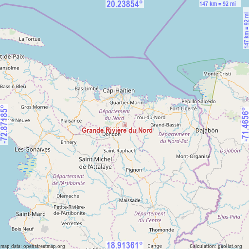
Grande Rivière du Nord GPS coordinates[2]
19° 34' 38.784" North, 72° 10' 7.392" West
| Map corner | latitude | longitude |
|---|---|---|
| Upper-left | 20.23854°, | -72.87185° |
| Center: | 19.57744°, | -72.16872° |
| Lower-right: | 18.91361°, | -71.4656° |
| Map W x H: | 147.3×147.3 km | = 91.5×91.5mi |
| max Lat: | 19.93984° ⇑28.3% North |
| Grande Rivière du Nord: | 19.57744° |
| min Lat: | ⇓71.7% South 18.05° |
| min Long | Grande Rivière | max Long |
| -74.4528° | -72.16872° | -71.72475° |
| W 71.7%⇐ | ⇒28.3% E |
Elevation
Elevation of Grande Rivière du Nord is 69 m = 226 ft, and this is 76.1 m = 250 ft below average elevation for this country.
| Max E: |
1466 m = 4810 ft | 38.7% |
| Avg. | 145.1 m = 476 ft | |
| Grande Rivière du Nord | 69 m = 226 ft | |
Min E: |
3 m = 10 ft | 61.3% |
See also: Haiti elevation on elevation.city.
Geographical zone
Grande Rivière du Nord is located in North Torrid zone (between Equator and Tropic of Cancer). Distance of this Northern Tropic circle is 429.1 km =266.6 mi to North.| Distance of | km | miles | from Grande Rivière du Nord |
|---|---|---|---|
| North Pole | 7830.3 | 4865.5 | to North |
| Arctic Circle | 5224.4 | 3246.3 | to North |
| Tropic Cancer | 429.1 | 266.6 | to North |
| Equator | 2176.8 | 1352.6 | to South |


Nearby cities:
15 places around Grande Rivière du Nord: (largest is in red/bold)
• Acul du Nord
19.6 km =12.2 mi,  305°
305°
• Bahon
13.3 km =8.3 mi,  154°
154°
• Caracol
20.4 km =12.7 mi,  51°
51°
• Dondon
9.6 km =6 mi,  234°
234°
• Limonade
11.3 km =7 mi,  24°
24°
• Marmelade
21.3 km =13.2 mi,  251°
251°
• Milot
5.8 km =3.6 mi, 306°
• Okap
20.5 km =12.7 mi,  351°
351°
• Perches
26.5 km =16.5 mi,  103°
103°
• Pignon
27.4 km =17 mi,  168°
168°
• Plaine du Nord
15.3 km =9.5 mi,  316°
316°
• Quartier Morin
13.3 km =8.3 mi,  5°
5°
• Ranquitte
20.4 km =12.7 mi, 153°
• Saint-Raphaël
15.7 km =9.8 mi,  191°
191°
• Trou du Nord
15.7 km =9.8 mi,  73°
73°
Sources, notices
• [Note1] Compared only with cities in Haiti existing in our database
• [Src1] Map data: © OpenStreetMap contributors (CC-BY-SA)
• [Src2] Other city data from geonames.org with taken over terms of usage.
• [Src3] Geographical zone / Annual Mean Temperature by Robert A. Rohde @ Wikipedia
