Bahon geodata
Bahon (Nord) is a populated place; located in Haiti in America/Port-au-Prince (GMT-4) time zone. With population of 1,618 people, there are 90 cities with bigger population in this country. Compared to other cities in Haiti, 65.1% of cities are located further ↓South; 76.4% of cities are located further ←West and 69.8% of cities have lower elevation than Bahon. Note1


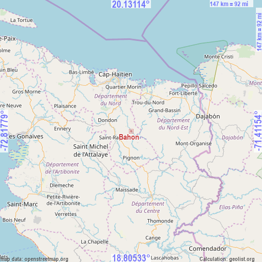
Bahon GPS coordinates[2]
19° 28' 10.524" North, 72° 6' 52.776" West
| Map corner | latitude | longitude |
|---|---|---|
| Upper-left | 20.13114°, | -72.81779° |
| Center: | 19.46959°, | -72.11466° |
| Lower-right: | 18.80533°, | -71.41154° |
| Map W x H: | 147.4×147.4 km | = 91.6×91.6mi |
| max Lat: | 19.93984° ⇑34.9% North |
| Bahon: | 19.46959° |
| min Lat: | ⇓65.1% South 18.05° |
| min Long | Bahon | max Long |
| -74.4528° | -72.11466° | -71.72475° |
| W 76.4%⇐ | ⇒23.6% E |
Elevation
Elevation of Bahon is 119 m = 390 ft, and this is 26.1 m = 86 ft below average elevation for this country.
| Max E: |
1466 m = 4810 ft | 30.2% |
| Avg. | 145.1 m = 476 ft | |
| Bahon | 119 m = 390 ft | |
Min E: |
3 m = 10 ft | 69.8% |
See also: Haiti elevation on elevation.city.
Geographical zone
Bahon is located in North Torrid zone (between Equator and Tropic of Cancer). Distance of this Northern Tropic circle is 441.1 km =274.1 mi to North.| Distance of | km | miles | from Bahon |
|---|---|---|---|
| North Pole | 7842.2 | 4872.9 | to North |
| Arctic Circle | 5236.4 | 3253.7 | to North |
| Tropic Cancer | 441.1 | 274.1 | to North |
| Equator | 2164.8 | 1345.1 | to South |


Nearby cities:
15 places around Bahon: (largest is in red/bold)
• Acul Samedi
25 km =15.5 mi,  77°
77°
• Caracol
26.8 km =16.7 mi,  22°
22°
• Carice
31.5 km =19.6 mi,  108°
108°
• Dondon
14.9 km =9.3 mi,  295°
295°
• Grande Rivière du Nord
13.3 km =8.3 mi,  334°
334°
• Limonade
22.3 km =13.9 mi,  357°
357°
• Marmelade
26.4 km =16.4 mi,  281°
281°
• Milot
18.6 km =11.6 mi, 326°
• Perches
20.9 km =13 mi,  73°
73°
• Pignon
14.9 km =9.3 mi,  180°
180°
• Plaine du Nord
28.2 km =17.5 mi,  324°
324°
• Quartier Morin
25.7 km =16 mi,  350°
350°
• Ranquitte
7.2 km =4.5 mi,  150°
150°
• Saint-Raphaël
9.5 km =5.9 mi,  248°
248°
• Trou du Nord
18.9 km =11.7 mi,  30°
30°
Sources, notices
• [Note1] Compared only with cities in Haiti existing in our database
• [Src1] Map data: © OpenStreetMap contributors (CC-BY-SA)
• [Src2] Other city data from geonames.org with taken over terms of usage.
• [Src3] Geographical zone / Annual Mean Temperature by Robert A. Rohde @ Wikipedia
