Limonade geodata
Limonade (Nord) is a populated place; located in Haiti in America/Port-au-Prince (GMT-4) time zone. With population of 3,810 people, there are 54 cities with bigger population in this country. Compared to other cities in Haiti, 83% of cities are located further ↓South; 74.5% of cities are located further ←West and 59.4% of cities have higher elevation than Limonade. Note1


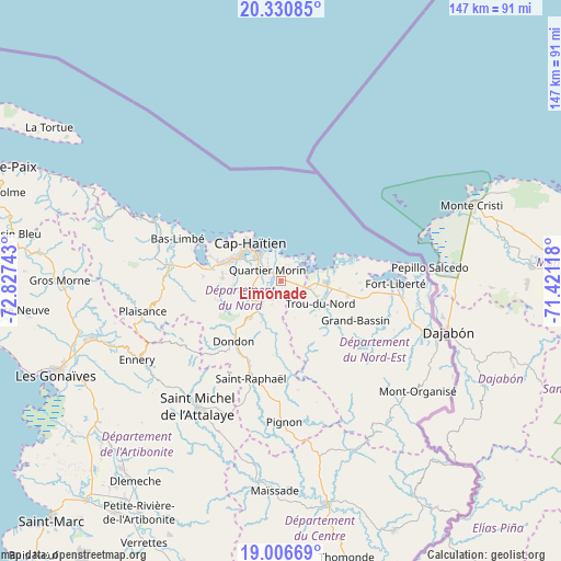
Limonade GPS coordinates[2]
19° 40' 12.504" North, 72° 7' 27.48" West
| Map corner | latitude | longitude |
|---|---|---|
| Upper-left | 20.33085°, | -72.82743° |
| Center: | 19.67014°, | -72.1243° |
| Lower-right: | 19.00669°, | -71.42118° |
| Map W x H: | 147.2×147.2 km | = 91.5×91.5mi |
| max Lat: | 19.93984° ⇑17% North |
| Limonade: | 19.67014° |
| min Lat: | ⇓83% South 18.05° |
| min Long | Limonade | max Long |
| -74.4528° | -72.1243° | -71.72475° |
| W 74.5%⇐ | ⇒25.5% E |
Elevation
Elevation of Limonade is 20 m = 66 ft, and this is 125.1 m = 410 ft below average elevation for this country.
| Max E: |
1466 m = 4810 ft | 59.4% |
| Avg. | 145.1 m = 476 ft | |
| Limonade | 20 m = 66 ft | |
Min E: |
3 m = 10 ft | 40.6% |
See also: Haiti elevation on elevation.city.
Geographical zone
Limonade is located in North Torrid zone (between Equator and Tropic of Cancer). Distance of this Northern Tropic circle is 418.8 km =260.2 mi to North.| Distance of | km | miles | from Limonade |
|---|---|---|---|
| North Pole | 7819.9 | 4859.1 | to North |
| Arctic Circle | 5214.1 | 3239.9 | to North |
| Tropic Cancer | 418.8 | 260.2 | to North |
| Equator | 2187.1 | 1359 | to South |


Nearby cities:
15 places around Limonade: (largest is in red/bold)
• Acul du Nord
20.5 km =12.7 mi,  273°
273°
• Bahon
22.3 km =13.9 mi,  177°
177°
• Caracol
11.5 km =7.1 mi,  77°
77°
• Dondon
20.2 km =12.6 mi,  218°
218°
• Grande Rivière du Nord
11.3 km =7 mi,  204°
204°
• Lenbe
29.5 km =18.3 mi,  277°
277°
• Milot
11.6 km =7.2 mi,  233°
233°
• Okap
12.6 km =7.8 mi,  322°
322°
• Perches
26.7 km =16.6 mi,  128°
128°
• Phaëton
23.8 km =14.8 mi,  88°
88°
• Plaine du Nord
15.2 km =9.4 mi, 272°
• Quartier Morin
4.5 km =2.8 mi,  310°
310°
• Ranquitte
28.9 km =18 mi,  170°
170°
• Saint-Raphaël
26.9 km =16.7 mi, 196°
• Trou du Nord
12 km =7.5 mi,  119°
119°
Sources, notices
• [Note1] Compared only with cities in Haiti existing in our database
• [Src1] Map data: © OpenStreetMap contributors (CC-BY-SA)
• [Src2] Other city data from geonames.org with taken over terms of usage.
• [Src3] Geographical zone / Annual Mean Temperature by Robert A. Rohde @ Wikipedia
