Port-au-Prince geodata
Port-au-Prince (Ouest) is a capital of a political entity; located in Haiti in America/Port-au-Prince (GMT-4) time zone. With population of 1,234,742 people, there are 0 cities with bigger population in this country. Compared to other cities in Haiti, 64.2% of cities are located further ↑North; 60.4% of cities are located further ←West and 57.5% of cities have lower elevation than Port-au-Prince. Note1


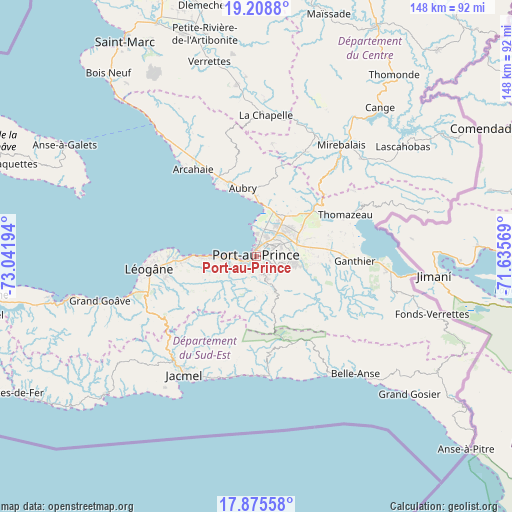
Port-au-Prince GPS coordinates[2]
18° 32' 36.564" North, 72° 20' 19.716" West
| Map corner | latitude | longitude |
|---|---|---|
| Upper-left | 19.2088°, | -73.04194° |
| Center: | 18.54349°, | -72.33881° |
| Lower-right: | 17.87558°, | -71.63569° |
| Map W x H: | 148.2×148.2 km | = 92.1×92.1mi |
| max Lat: | 19.93984° ⇑64.2% North |
| Port-au-Prince: | 18.54349° |
| min Lat: | ⇓35.8% South 18.05° |
| min Long | Port-au-Prince | max Long |
| -74.4528° | -72.33881° | -71.72475° |
| W 60.4%⇐ | ⇒39.6% E |
Elevation
Elevation of Port-au-Prince is 53 m = 174 ft, and this is 92.1 m = 302 ft below average elevation for this country.
| Max E: |
1466 m = 4810 ft | 42.5% |
| Avg. | 145.1 m = 476 ft | |
| Port-au-Prince | 53 m = 174 ft | |
Min E: |
3 m = 10 ft | 57.5% |
See also: Port-au-Prince elevation on elevation.city.
Geographical zone
Port-au-Prince is located in North Torrid zone (between Equator and Tropic of Cancer). Distance of this Northern Tropic circle is 544.1 km =338.1 mi to North.| Distance of | km | miles | from Port-au-Prince |
|---|---|---|---|
| North Pole | 7945.2 | 4936.9 | to North |
| Arctic Circle | 5339.3 | 3317.7 | to North |
| Tropic Cancer | 544.1 | 338.1 | to North |
| Equator | 2061.8 | 1281.1 | to South |


Nearby cities:
15 places around Port-au-Prince: (largest is in red/bold)
• Cabaret
23 km =14.3 mi,  338°
338°
• Carrefour
6.4 km =4 mi,  267°
267°
• Cayes-Jacmel
35.2 km =21.9 mi,  189°
189°
• Cornillon
43.3 km =26.9 mi,  70°
70°
• Croix-des-Bouquets
12.4 km =7.7 mi, 72°
• Delmas 73
3.8 km =2.4 mi,  87°
87°
• Fond Parisien
37.9 km =23.5 mi,  96°
96°
• Gressier
19.8 km =12.3 mi, 269°
• Jacmel
40.2 km =25 mi,  211°
211°
• Kenscoff
12.1 km =7.5 mi,  151°
151°
• Léogâne
31.3 km =19.4 mi,  263°
263°
• Marigot
34.7 km =21.6 mi,  177°
177°
• Mirebalais
40.7 km =25.3 mi,  37°
37°
• Pétionville
6.6 km =4.1 mi,  121°
121°
• Thomazeau
28.5 km =17.7 mi,  64°
64°
Sources, notices
• [Note1] Compared only with cities in Haiti existing in our database
• [Src1] Map data: © OpenStreetMap contributors (CC-BY-SA)
• [Src2] Other city data from geonames.org with taken over terms of usage.
• [Src3] Geographical zone / Annual Mean Temperature by Robert A. Rohde @ Wikipedia
