Kenscoff geodata
Kenscoff (Ouest) is a populated place; located in Haiti in America/Port-au-Prince (GMT-4) time zone. With population of 42,175 people, there are 18 cities with bigger population in this country. Compared to other cities in Haiti, 73.6% of cities are located further ↑North; 65.1% of cities are located further ←West and 100% of cities have lower elevation than Kenscoff. Note1


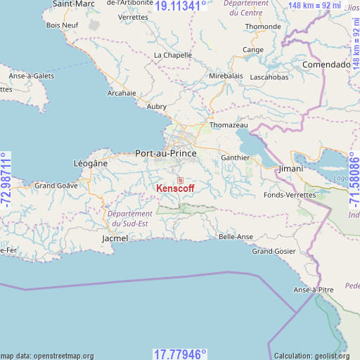
Kenscoff GPS coordinates[2]
18° 26' 51.828" North, 72° 17' 2.328" West
| Map corner | latitude | longitude |
|---|---|---|
| Upper-left | 19.11341°, | -72.98711° |
| Center: | 18.44773°, | -72.28398° |
| Lower-right: | 17.77946°, | -71.58086° |
| Map W x H: | 148.3×148.3 km | = 92.1×92.1mi |
| max Lat: | 19.93984° ⇑73.6% North |
| Kenscoff: | 18.44773° |
| min Lat: | ⇓26.4% South 18.05° |
| min Long | Kenscoff | max Long |
| -74.4528° | -72.28398° | -71.72475° |
| W 65.1%⇐ | ⇒34.9% E |
Elevation
Elevation of Kenscoff is 1466 m = 4810 ft, and this is 1320.9 m = 4334 ft above average elevation for this country.
| Max E: |
1466 m = 4810 ft | 0% |
| Kenscoff | 1466 m 4810 ft | |
| Avg. | 145.1 m = 476 ft | |
Min E: |
3 m = 10 ft | 100% |
See also: Kenscoff elevation on elevation.city.
Geographical zone
Kenscoff is located in North Torrid zone (between Equator and Tropic of Cancer). Distance of this Northern Tropic circle is 554.7 km =344.7 mi to North.| Distance of | km | miles | from Kenscoff |
|---|---|---|---|
| North Pole | 7955.9 | 4943.6 | to North |
| Arctic Circle | 5350 | 3324.3 | to North |
| Tropic Cancer | 554.7 | 344.7 | to North |
| Equator | 2051.2 | 1274.6 | to South |


Nearby cities:
15 places around Kenscoff: (largest is in red/bold)
• Belle-Anse
32.8 km =20.4 mi,  135°
135°
• Cabaret
35.1 km =21.8 mi,  336°
336°
• Carrefour
16 km =9.9 mi,  310°
310°
• Cayes-Jacmel
26.8 km =16.7 mi,  206°
206°
• Cornillon
43.1 km =26.8 mi,  54°
54°
• Croix-des-Bouquets
15.6 km =9.7 mi,  22°
22°
• Delmas 73
11 km =6.8 mi,  349°
349°
• Fond Parisien
32.6 km =20.3 mi,  78°
78°
• Gressier
27.6 km =17.1 mi,  292°
292°
• Jacmel
35.6 km =22.1 mi,  228°
228°
• Léogâne
37.5 km =23.3 mi,  280°
280°
• Marigot
24.4 km =15.2 mi,  189°
189°
• Port-au-Prince
12.1 km =7.5 mi,  331°
331°
• Pétionville
7.2 km =4.5 mi,  358°
358°
• Thomazeau
30.4 km =18.9 mi,  41°
41°
Sources, notices
• [Note1] Compared only with cities in Haiti existing in our database
• [Src1] Map data: © OpenStreetMap contributors (CC-BY-SA)
• [Src2] Other city data from geonames.org with taken over terms of usage.
• [Src3] Geographical zone / Annual Mean Temperature by Robert A. Rohde @ Wikipedia
