Cornillon geodata
Cornillon (Ouest) is a populated place; located in Haiti in America/Port-au-Prince (GMT-4) time zone. With population of 7,572 people, there are 35 cities with bigger population in this country. Compared to other cities in Haiti, 54.7% of cities are located further ↑North; 85.8% of cities are located further ←West and 99.1% of cities have lower elevation than Cornillon. Note1


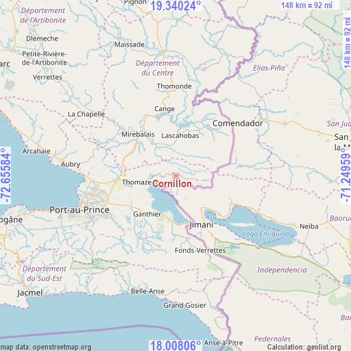
Cornillon GPS coordinates[2]
18° 40' 31.656" North, 71° 57' 9.756" West
| Map corner | latitude | longitude |
|---|---|---|
| Upper-left | 19.34024°, | -72.65584° |
| Center: | 18.67546°, | -71.95271° |
| Lower-right: | 18.00806°, | -71.24959° |
| Map W x H: | 148.1×148.1 km | = 92×92mi |
| max Lat: | 19.93984° ⇑54.7% North |
| Cornillon: | 18.67546° |
| min Lat: | ⇓45.3% South 18.05° |
| min Long | Cornillon | max Long |
| -74.4528° | -71.95271° | -71.72475° |
| W 85.8%⇐ | ⇒14.2% E |
Elevation
Elevation of Cornillon is 944 m = 3097 ft, and this is 798.9 m = 2621 ft above average elevation for this country.
| Max E: |
1466 m = 4810 ft | 0.90000000000001% |
| Cornillon | 944 m 3097 ft | |
| Avg. | 145.1 m = 476 ft | |
Min E: |
3 m = 10 ft | 99.1% |
See also: Haiti elevation on elevation.city.
Geographical zone
Cornillon is located in North Torrid zone (between Equator and Tropic of Cancer). Distance of this Northern Tropic circle is 529.4 km =329 mi to North.| Distance of | km | miles | from Cornillon |
|---|---|---|---|
| North Pole | 7930.5 | 4927.8 | to North |
| Arctic Circle | 5324.7 | 3308.6 | to North |
| Tropic Cancer | 529.4 | 329 | to North |
| Equator | 2076.5 | 1290.3 | to South |


Nearby cities:
15 places around Cornillon: (largest is in red/bold)
• Cabaret
49.6 km =30.8 mi,  277°
277°
• Carrefour
49.4 km =30.7 mi,  252°
252°
• Croix-des-Bouquets
30.8 km =19.1 mi, 249°
• Delmas 73
39.6 km =24.6 mi, 248°
• Fond Parisien
19.1 km =11.9 mi,  189°
189°
• Fonds Verrettes
32.7 km =20.3 mi,  161°
161°
• Kenscoff
43.1 km =26.8 mi,  234°
234°
• Lascahobas
17.3 km =10.7 mi,  5°
5°
• Mirebalais
23.9 km =14.9 mi,  317°
317°
• Port-au-Prince
43.3 km =26.9 mi, 250°
• Pétionville
39.5 km =24.5 mi,  242°
242°
• Thiotte
49.4 km =30.7 mi,  166°
166°
• Thomassique
46.8 km =29.1 mi, 14°
• Thomazeau
15.1 km =9.4 mi,  260°
260°
• Thomonde
38 km =23.6 mi,  358°
358°
Sources, notices
• [Note1] Compared only with cities in Haiti existing in our database
• [Src1] Map data: © OpenStreetMap contributors (CC-BY-SA)
• [Src2] Other city data from geonames.org with taken over terms of usage.
• [Src3] Geographical zone / Annual Mean Temperature by Robert A. Rohde @ Wikipedia
