Thomazeau geodata
Thomazeau (Ouest) is a populated place; located in Haiti in America/Port-au-Prince (GMT-4) time zone. With population of 52,017 people, there are 15 cities with bigger population in this country. Compared to other cities in Haiti, 55.7% of cities are located further ↑North; 78.3% of cities are located further ←West and 54.7% of cities have lower elevation than Thomazeau. Note1


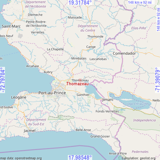
Thomazeau GPS coordinates[2]
18° 39' 10.692" North, 72° 5' 38.076" West
| Map corner | latitude | longitude |
|---|---|---|
| Upper-left | 19.31784°, | -72.79704° |
| Center: | 18.65297°, | -72.09391° |
| Lower-right: | 17.98548°, | -71.39079° |
| Map W x H: | 148.1×148.1 km | = 92×92mi |
| max Lat: | 19.93984° ⇑55.7% North |
| Thomazeau: | 18.65297° |
| min Lat: | ⇓44.3% South 18.05° |
| min Long | Thomazeau | max Long |
| -74.4528° | -72.09391° | -71.72475° |
| W 78.3%⇐ | ⇒21.7% E |
Elevation
Elevation of Thomazeau is 46 m = 151 ft, and this is 99.1 m = 325 ft below average elevation for this country.
| Max E: |
1466 m = 4810 ft | 45.3% |
| Avg. | 145.1 m = 476 ft | |
| Thomazeau | 46 m = 151 ft | |
Min E: |
3 m = 10 ft | 54.7% |
See also: Thomazeau elevation on elevation.city.
Geographical zone
Thomazeau is located in North Torrid zone (between Equator and Tropic of Cancer). Distance of this Northern Tropic circle is 531.9 km =330.5 mi to North.| Distance of | km | miles | from Thomazeau |
|---|---|---|---|
| North Pole | 7933 | 4929.3 | to North |
| Arctic Circle | 5327.2 | 3310.2 | to North |
| Tropic Cancer | 531.9 | 330.5 | to North |
| Equator | 2074 | 1288.7 | to South |


Nearby cities:
15 places around Thomazeau: (largest is in red/bold)
• Belle-Anse
46.3 km =28.8 mi,  176°
176°
• Cabaret
35.5 km =22.1 mi,  285°
285°
• Carrefour
34.5 km =21.4 mi,  248°
248°
• Cornillon
15.1 km =9.4 mi,  80°
80°
• Croix-des-Bouquets
16.3 km =10.1 mi,  238°
238°
• Delmas 73
25.1 km =15.6 mi, 241°
• Fond Parisien
20.2 km =12.6 mi,  144°
144°
• Fonds Verrettes
38 km =23.6 mi, 138°
• Gressier
47.3 km =29.4 mi, 254°
• Kenscoff
30.4 km =18.9 mi,  221°
221°
• Lascahobas
25.8 km =16 mi,  40°
40°
• Mirebalais
20.2 km =12.6 mi,  356°
356°
• Port-au-Prince
28.5 km =17.7 mi, 244°
• Pétionville
25.5 km =15.8 mi,  232°
232°
• Thomonde
42.8 km =26.6 mi,  18°
18°
Sources, notices
• [Note1] Compared only with cities in Haiti existing in our database
• [Src1] Map data: © OpenStreetMap contributors (CC-BY-SA)
• [Src2] Other city data from geonames.org with taken over terms of usage.
• [Src3] Geographical zone / Annual Mean Temperature by Robert A. Rohde @ Wikipedia
