Anse-à-Veau geodata
Anse-à-Veau (GrandʼAnse) is a populated place; located in Haiti in America/Port-au-Prince (GMT-4) time zone. With population of 1,731 people, there are 85 cities with bigger population in this country. Compared to other cities in Haiti, 70.8% of cities are located further ↑North; 76.4% of cities are located further →East and 67.9% of cities have higher elevation than Anse-à-Veau. Note1


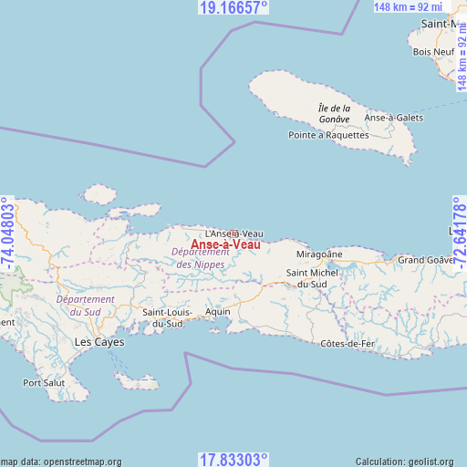
Anse-à-Veau GPS coordinates[2]
18° 30' 3.96" North, 73° 20' 41.64" West
| Map corner | latitude | longitude |
|---|---|---|
| Upper-left | 19.16657°, | -74.04803° |
| Center: | 18.5011°, | -73.3449° |
| Lower-right: | 17.83303°, | -72.64178° |
| Map W x H: | 148.3×148.3 km | = 92.1×92.1mi |
| max Lat: | 19.93984° ⇑70.8% North |
| Anse-à-Veau: | 18.5011° |
| min Lat: | ⇓29.2% South 18.05° |
| min Long | Anse-à-Veau | max Long |
| -74.4528° | -73.3449° | -71.72475° |
| W 23.6%⇐ | ⇒76.4% E |
Elevation
Elevation of Anse-à-Veau is 16 m = 52 ft, and this is 129.1 m = 424 ft below average elevation for this country.
| Max E: |
1466 m = 4810 ft | 67.9% |
| Avg. | 145.1 m = 476 ft | |
| Anse-à-Veau | 16 m = 52 ft | |
Min E: |
3 m = 10 ft | 32.1% |
See also: Haiti elevation on elevation.city.
Geographical zone
Anse-à-Veau is located in North Torrid zone (between Equator and Tropic of Cancer). Distance of this Northern Tropic circle is 548.8 km =341 mi to North.| Distance of | km | miles | from Anse-à-Veau |
|---|---|---|---|
| North Pole | 7949.9 | 4939.8 | to North |
| Arctic Circle | 5344 | 3320.6 | to North |
| Tropic Cancer | 548.8 | 341 | to North |
| Equator | 2057.1 | 1278.2 | to South |


Nearby cities:
15 places around Anse-à-Veau: (largest is in red/bold)
• Aquin
25.2 km =15.7 mi,  191°
191°
• Baradères
31.1 km =19.3 mi,  266°
266°
• Camp Perrin
58.4 km =36.3 mi,  250°
250°
• Cavaillon
39.6 km =24.6 mi,  235°
235°
• Corail
57.9 km =36 mi,  277°
277°
• Fond des Blancs
33.8 km =21 mi,  137°
137°
• Grangwav
61.2 km =38 mi,  97°
97°
• Kotdefè
50.1 km =31.1 mi,  133°
133°
• Lazil
14.9 km =9.3 mi,  209°
209°
• Les Cayes
54.4 km =33.8 mi,  231°
231°
• Miragoâne
27.6 km =17.1 mi, 102°
• Petit Trou de Nippes
17.4 km =10.8 mi, 278°
• Petite Rivière de Nippes
11.9 km =7.4 mi, 103°
• Saint-Louis du Sud
34 km =21.1 mi,  218°
218°
• Tigwav
51.2 km =31.8 mi, 98°
Sources, notices
• [Note1] Compared only with cities in Haiti existing in our database
• [Src1] Map data: © OpenStreetMap contributors (CC-BY-SA)
• [Src2] Other city data from geonames.org with taken over terms of usage.
• [Src3] Geographical zone / Annual Mean Temperature by Robert A. Rohde @ Wikipedia
