Lazil geodata
Lazil (Nippes) is a populated place; located in Haiti in America/Port-au-Prince (GMT-4) time zone. With population of 778 people, there are 104 cities with bigger population in this country. Compared to other cities in Haiti, 79.2% of cities are located further ↑North; 79.2% of cities are located further →East and 74.5% of cities have lower elevation than Lazil. Note1


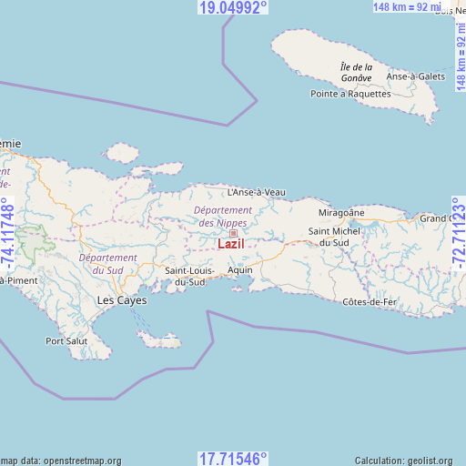
Lazil GPS coordinates[2]
18° 23' 2.328" North, 73° 24' 51.66" West
| Map corner | latitude | longitude |
|---|---|---|
| Upper-left | 19.04992°, | -74.11748° |
| Center: | 18.38398°, | -73.41435° |
| Lower-right: | 17.71546°, | -72.71123° |
| Map W x H: | 148.4×148.4 km | = 92.2×92.2mi |
| max Lat: | 19.93984° ⇑79.2% North |
| Lazil: | 18.38398° |
| min Lat: | ⇓20.8% South 18.05° |
| min Long | Lazil | max Long |
| -74.4528° | -73.41435° | -71.72475° |
| W 20.8%⇐ | ⇒79.2% E |
Elevation
Elevation of Lazil is 146 m = 479 ft, and this is 0.90000000000001 m = 3 ft above average elevation for this country.
| Max E: |
1466 m = 4810 ft | 25.5% |
| Lazil | 146 m 479 ft | |
| Avg. | 145.1 m = 476 ft | |
Min E: |
3 m = 10 ft | 74.5% |
See also: Haiti elevation on elevation.city.
Geographical zone
Lazil is located in North Torrid zone (between Equator and Tropic of Cancer). Distance of this Northern Tropic circle is 561.8 km =349.1 mi to North.| Distance of | km | miles | from Lazil |
|---|---|---|---|
| North Pole | 7963 | 4948 | to North |
| Arctic Circle | 5357.1 | 3328.7 | to North |
| Tropic Cancer | 561.8 | 349.1 | to North |
| Equator | 2044.1 | 1270.1 | to South |


Nearby cities:
15 places around Lazil: (largest is in red/bold)
• Anse-à-Veau
14.9 km =9.3 mi,  29°
29°
• Aquin
11.8 km =7.3 mi,  169°
169°
• Baradères
26.1 km =16.2 mi,  294°
294°
• Camp Perrin
48.2 km =30 mi,  262°
262°
• Cavaillon
27 km =16.8 mi,  249°
249°
• Chantal
54.1 km =33.6 mi, 248°
• Corail
54.1 km =33.6 mi, 292°
• Fond des Blancs
32.5 km =20.2 mi,  111°
111°
• Kotdefè
48.6 km =30.2 mi,  116°
116°
• Les Cayes
40.9 km =25.4 mi,  238°
238°
• Miragoâne
34.9 km =21.7 mi,  78°
78°
• Petit Trou de Nippes
18.6 km =11.6 mi,  327°
327°
• Petite Rivière de Nippes
21.5 km =13.4 mi,  61°
61°
• Saint-Louis du Sud
19.4 km =12.1 mi,  225°
225°
• Torbeck
48.4 km =30.1 mi, 239°
Sources, notices
• [Note1] Compared only with cities in Haiti existing in our database
• [Src1] Map data: © OpenStreetMap contributors (CC-BY-SA)
• [Src2] Other city data from geonames.org with taken over terms of usage.
• [Src3] Geographical zone / Annual Mean Temperature by Robert A. Rohde @ Wikipedia
