Carice geodata
Carice (Nord-Est) is a populated place; located in Haiti in America/Port-au-Prince (GMT-4) time zone. With population of 2,104 people, there are 73 cities with bigger population in this country. Compared to other cities in Haiti, 60.4% of cities are located further ↓South; 94.3% of cities are located further ←West and 94.3% of cities have lower elevation than Carice. Note1


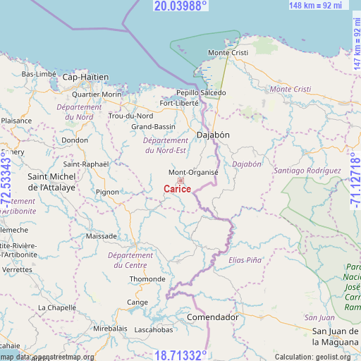
Carice GPS coordinates[2]
19° 22' 40.62" North, 71° 49' 49.08" West
| Map corner | latitude | longitude |
|---|---|---|
| Upper-left | 20.03988°, | -72.53343° |
| Center: | 19.37795°, | -71.8303° |
| Lower-right: | 18.71332°, | -71.12718° |
| Map W x H: | 147.5×147.5 km | = 91.7×91.7mi |
| max Lat: | 19.93984° ⇑39.6% North |
| Carice: | 19.37795° |
| min Lat: | ⇓60.4% South 18.05° |
| min Long | Carice | max Long |
| -74.4528° | -71.8303° | -71.72475° |
| W 94.3%⇐ | ⇒5.7% E |
Elevation
Elevation of Carice is 626 m = 2054 ft, and this is 480.9 m = 1578 ft above average elevation for this country.
| Max E: |
1466 m = 4810 ft | 5.7% |
| Carice | 626 m 2054 ft | |
| Avg. | 145.1 m = 476 ft | |
Min E: |
3 m = 10 ft | 94.3% |
See also: Haiti elevation on elevation.city.
Geographical zone
Carice is located in North Torrid zone (between Equator and Tropic of Cancer). Distance of this Northern Tropic circle is 451.3 km =280.4 mi to North.| Distance of | km | miles | from Carice |
|---|---|---|---|
| North Pole | 7852.4 | 4879.3 | to North |
| Arctic Circle | 5246.5 | 3260 | to North |
| Tropic Cancer | 451.3 | 280.4 | to North |
| Equator | 2154.6 | 1338.8 | to South |


Nearby cities:
15 places around Carice: (largest is in red/bold)
• Acul Samedi
16.6 km =10.3 mi,  340°
340°
• Bahon
31.5 km =19.6 mi,  288°
288°
• Cerca la Source
23.8 km =14.8 mi,  169°
169°
• Dérac
30.8 km =19.1 mi,  3°
3°
• Ferrier
27 km =16.8 mi,  11°
11°
• Fort Liberté
31.7 km =19.7 mi,  358°
358°
• Hinche
32 km =19.9 mi,  217°
217°
• Montòrganize
6.1 km =3.8 mi,  56°
56°
• Ouanaminthe
22 km =13.7 mi,  30°
30°
• Perches
18.7 km =11.6 mi,  328°
328°
• Phaëton
33.8 km =21 mi,  348°
348°
• Pignon
30.4 km =18.9 mi,  261°
261°
• Ranquitte
26.6 km =16.5 mi,  278°
278°
• Thomassique
32.9 km =20.4 mi,  181°
181°
• Trou du Nord
33.4 km =20.8 mi,  322°
322°
Sources, notices
• [Note1] Compared only with cities in Haiti existing in our database
• [Src1] Map data: © OpenStreetMap contributors (CC-BY-SA)
• [Src2] Other city data from geonames.org with taken over terms of usage.
• [Src3] Geographical zone / Annual Mean Temperature by Robert A. Rohde @ Wikipedia
