Sásd geodata
Sásd (Baranya) is a seat of a second-order administrative division; located in Hungary in Europe/Budapest (GMT+2) time zone. With population of 3,500 people, there are 414 cities with bigger population in this country. Compared to other cities in Hungary, 93.6% of cities are located further ↑North; 84.6% of cities are located further →East and 67.7% of cities have lower elevation than Sásd. Note1


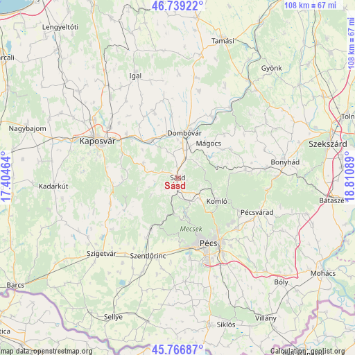
Sásd GPS coordinates[2]
46° 15' 18.72" North, 18° 6' 27.936" East
| Map corner | latitude | longitude |
|---|---|---|
| Upper-left | 46.73922°, | 17.40464° |
| Center: | 46.2552°, | 18.10776° |
| Lower-right: | 45.76687°, | 18.81089° |
| Map W x H: | 108.1×108.1 km | = 67.2×67.2mi |
| max Lat: | 48.46667° ⇑93.6% North |
| Sásd: | 46.2552° |
| min Lat: | ⇓6.4% South 45.79108° |
| min Long | Sásd | max Long |
| 16.27358° | 18.10776° | 22.68096° |
| W 15.4%⇐ | ⇒84.6% E |
Elevation
Elevation of Sásd is 134 m = 440 ft, and this is 4.3 m = 14 ft above average elevation for this country.
| Max E: |
444 m = 1457 ft | 32.3% |
| Sásd | 134 m 440 ft | |
| Avg. | 129.7 m = 426 ft | |
Min E: |
71 m = 233 ft | 67.7% |
See also: Hungary elevation on elevation.city.
Geographical zone
Sásd is located in North temperate zone (between Tropic of Cancer and the Arctic Circle). Distance of this North polar circle is 2258.1 km =1403.1 mi to North.| Distance of | km | miles | from Sásd |
|---|---|---|---|
| North Pole | 4864 | 3022.3 | to North |
| Arctic Circle | 2258.1 | 1403.1 | to North |
| Tropic Cancer | 2537.2 | 1576.5 | to South |
| Equator | 5143.1 | 3195.8 | to South |


Nearby cities:
15 places around Sásd: (largest is in red/bold)
• Bükkösd
18.8 km =11.7 mi,  209°
209°
• Dombóvár
13.7 km =8.5 mi,  9°
9°
• Döbrököz
21.1 km =13.1 mi,  28°
28°
• Gödre
10.9 km =6.8 mi,  288°
288°
• Hosszúhetény
21.3 km =13.2 mi,  118°
118°
• Kaposvár
26.7 km =16.6 mi,  297°
297°
• Komló
13.9 km =8.6 mi, 119°
• Mágocs
14.2 km =8.8 mi,  42°
42°
• Nagymányok
26.8 km =16.7 mi,  84°
84°
• Pellérd
24.8 km =15.4 mi,  171°
171°
• Pécs
21.4 km =13.3 mi,  153°
153°
• Pécsvárad
26.5 km =16.5 mi,  113°
113°
• Szentlőrinc
25.7 km =16 mi,  201°
201°
• Szászvár
20.7 km =12.9 mi, 83°
• Taszár
20.4 km =12.7 mi,  310°
310°
Sources, notices
• [Note1] Compared only with cities in Hungary existing in our database
• [Src1] Map data: © OpenStreetMap contributors (CC-BY-SA)
• [Src2] Other city data from geonames.org with taken over terms of usage.
• [Src3] Geographical zone / Annual Mean Temperature by Robert A. Rohde @ Wikipedia
