Komló geodata
Komló (Baranya) is a populated place; located in Hungary in Europe/Budapest (GMT+2) time zone. With population of 26,924 people, there are 64 cities with bigger population in this country. Compared to other cities in Hungary, 96% of cities are located further ↑North; 81.4% of cities are located further →East and 97% of cities have lower elevation than Komló. Note1


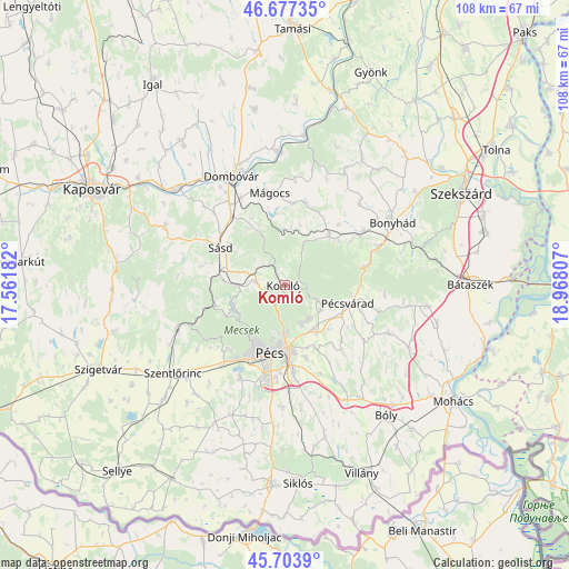
Komló GPS coordinates[2]
46° 11' 34.008" North, 18° 15' 53.784" East
| Map corner | latitude | longitude |
|---|---|---|
| Upper-left | 46.67735°, | 17.56182° |
| Center: | 46.19278°, | 18.26494° |
| Lower-right: | 45.7039°, | 18.96807° |
| Map W x H: | 108.2×108.2 km | = 67.2×67.2mi |
| max Lat: | 48.46667° ⇑96% North |
| Komló: | 46.19278° |
| min Lat: | ⇓4% South 45.79108° |
| min Long | Komló | max Long |
| 16.27358° | 18.26494° | 22.68096° |
| W 18.6%⇐ | ⇒81.4% E |
Elevation
Elevation of Komló is 246 m = 807 ft, and this is 116.3 m = 382 ft above average elevation for this country.
| Max E: |
444 m = 1457 ft | 3% |
| Komló | 246 m 807 ft | |
| Avg. | 129.7 m = 426 ft | |
Min E: |
71 m = 233 ft | 97% |
See also: Hungary elevation on elevation.city.
Geographical zone
Komló is located in North temperate zone (between Tropic of Cancer and the Arctic Circle). Distance of this North polar circle is 2265 km =1407.4 mi to North.| Distance of | km | miles | from Komló |
|---|---|---|---|
| North Pole | 4870.9 | 3026.6 | to North |
| Arctic Circle | 2265 | 1407.4 | to North |
| Tropic Cancer | 2530.2 | 1572.2 | to South |
| Equator | 5136.2 | 3191.5 | to South |


Nearby cities:
15 places around Komló: (largest is in red/bold)
• Bonyhád
23.6 km =14.7 mi,  59°
59°
• Bükkösd
23.3 km =14.5 mi,  246°
246°
• Dombóvár
22.7 km =14.1 mi,  334°
334°
• Gödre
24.7 km =15.3 mi,  294°
294°
• Hidas
19.1 km =11.9 mi,  68°
68°
• Hosszúhetény
7.3 km =4.5 mi,  115°
115°
• Kozármisleny
18.3 km =11.4 mi,  173°
173°
• Mecseknádasd
16.2 km =10.1 mi,  77°
77°
• Mágocs
17.7 km =11 mi,  351°
351°
• Nagymányok
17.5 km =10.9 mi, 56°
• Pellérd
19.6 km =12.2 mi,  205°
205°
• Pécs
12.4 km =7.7 mi,  191°
191°
• Pécsvárad
12.7 km =7.9 mi,  106°
106°
• Szászvár
12.6 km =7.8 mi,  42°
42°
• Sásd
13.9 km =8.6 mi,  299°
299°
Sources, notices
• [Note1] Compared only with cities in Hungary existing in our database
• [Src1] Map data: © OpenStreetMap contributors (CC-BY-SA)
• [Src2] Other city data from geonames.org with taken over terms of usage.
• [Src3] Geographical zone / Annual Mean Temperature by Robert A. Rohde @ Wikipedia
