Pilisszántó geodata
Pilisszántó (Pest) is a populated place; located in Hungary in Europe/Budapest (GMT+2) time zone. With population of 2,245 people, there are 693 cities with bigger population in this country. Compared to other cities in Hungary, 68% of cities are located further ↓South; 68.9% of cities are located further →East and 95% of cities have lower elevation than Pilisszántó. Note1


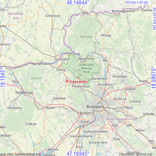
Pilisszántó GPS coordinates[2]
47° 40' 8.724" North, 18° 53' 15.432" East
| Map corner | latitude | longitude |
|---|---|---|
| Upper-left | 48.14044°, | 18.1845° |
| Center: | 47.66909°, | 18.88762° |
| Lower-right: | 47.19345°, | 19.59075° |
| Map W x H: | 105.3×105.3 km | = 65.4×65.4mi |
| max Lat: | 48.46667° ⇑32% North |
| Pilisszántó: | 47.66909° |
| min Lat: | ⇓68% South 45.79108° |
| min Long | Pilisszántó | max Long |
| 16.27358° | 18.88762° | 22.68096° |
| W 31.1%⇐ | ⇒68.9% E |
Elevation
Elevation of Pilisszántó is 223 m = 732 ft, and this is 93.3 m = 306 ft above average elevation for this country.
| Max E: |
444 m = 1457 ft | 5% |
| Pilisszántó | 223 m 732 ft | |
| Avg. | 129.7 m = 426 ft | |
Min E: |
71 m = 233 ft | 95% |
See also: Hungary elevation on elevation.city.
Geographical zone
Pilisszántó is located in North temperate zone (between Tropic of Cancer and the Arctic Circle). Distance of this North polar circle is 2100.9 km =1305.4 mi to North.| Distance of | km | miles | from Pilisszántó |
|---|---|---|---|
| North Pole | 4706.8 | 2924.7 | to North |
| Arctic Circle | 2100.9 | 1305.4 | to North |
| Tropic Cancer | 2694.4 | 1674.2 | to South |
| Equator | 5300.3 | 3293.5 | to South |


Nearby cities:
15 places around Pilisszántó: (largest is in red/bold)
• Csobánka
6.1 km =3.8 mi,  114°
114°
• Dorog
12.7 km =7.9 mi,  297°
297°
• Kesztölc
8 km =5 mi,  307°
307°
• Nagykovácsi
9.9 km =6.2 mi,  102°
102°
• Pilisborosjenő
10.5 km =6.5 mi,  130°
130°
• Piliscsaba
5.9 km =3.7 mi,  228°
228°
• Piliscsév
5.3 km =3.3 mi,  282°
282°
• Pilismarót
12.9 km =8 mi,  355°
355°
• Pilisszentiván
6.7 km =4.2 mi,  172°
172°
• Pilisszentkereszt
2.8 km =1.7 mi,  27°
27°
• Pilisvörösvár
6.3 km =3.9 mi, 165°
• Pomáz
10.9 km =6.8 mi, 105°
• Remeteszőlős
12.3 km =7.6 mi, 168°
• Solymár
9.1 km =5.7 mi,  158°
158°
• Üröm
12.5 km =7.8 mi, 129°
Sources, notices
• [Note1] Compared only with cities in Hungary existing in our database
• [Src1] Map data: © OpenStreetMap contributors (CC-BY-SA)
• [Src2] Other city data from geonames.org with taken over terms of usage.
• [Src3] Geographical zone / Annual Mean Temperature by Robert A. Rohde @ Wikipedia
