Ruzsa geodata
Ruzsa (Csongrád) is a populated place; located in Hungary in Europe/Budapest (GMT+2) time zone. With population of 2,764 people, there are 546 cities with bigger population in this country. Compared to other cities in Hungary, 92.3% of cities are located further ↑North; 56.3% of cities are located further ←West and 54.7% of cities have higher elevation than Ruzsa. Note1


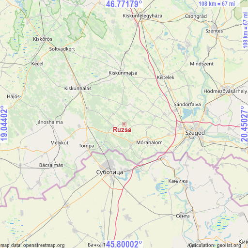
Ruzsa GPS coordinates[2]
46° 17' 17.016" North, 19° 44' 49.704" East
| Map corner | latitude | longitude |
|---|---|---|
| Upper-left | 46.77179°, | 19.04402° |
| Center: | 46.28806°, | 19.74714° |
| Lower-right: | 45.80002°, | 20.45027° |
| Map W x H: | 108.1×10⁸ km | = 67.2×67.1mi |
| max Lat: | 48.46667° ⇑92.3% North |
| Ruzsa: | 46.28806° |
| min Lat: | ⇓7.7% South 45.79108° |
| min Long | Ruzsa | max Long |
| 16.27358° | 19.74714° | 22.68096° |
| W 56.3%⇐ | ⇒43.7% E |
Elevation
Elevation of Ruzsa is 113 m = 371 ft, and this is 16.7 m = 55 ft below average elevation for this country.
| Max E: |
444 m = 1457 ft | 54.7% |
| Avg. | 129.7 m = 426 ft | |
| Ruzsa | 113 m = 371 ft | |
Min E: |
71 m = 233 ft | 45.3% |
See also: Hungary elevation on elevation.city.
Geographical zone
Ruzsa is located in North temperate zone (between Tropic of Cancer and the Arctic Circle). Distance of this North polar circle is 2254.4 km =1400.8 mi to North.| Distance of | km | miles | from Ruzsa |
|---|---|---|---|
| North Pole | 4860.3 | 3020 | to North |
| Arctic Circle | 2254.4 | 1400.8 | to North |
| Tropic Cancer | 2540.8 | 1578.8 | to South |
| Equator | 5146.7 | 3198 | to South |


Nearby cities:
15 places around Ruzsa: (largest is in red/bold)
• Balástya
25 km =15.5 mi,  53°
53°
• Bordány
13.9 km =8.6 mi,  75°
75°
• Domaszék
20.7 km =12.9 mi,  102°
102°
• Forráskút
15.2 km =9.4 mi,  55°
55°
• Kelebia
14.3 km =8.9 mi,  224°
224°
• Kiskunmajsa
22.5 km =14 mi,  358°
358°
• Kisszállás
19.8 km =12.3 mi,  267°
267°
• Mórahalom
13.2 km =8.2 mi,  126°
126°
• Röszke
24.7 km =15.3 mi,  116°
116°
• Szatymaz
23.3 km =14.5 mi,  74°
74°
• Tompa
18.4 km =11.4 mi,  240°
240°
• Zsombó
18 km =11.2 mi, 76°
• Zákányszék
11.1 km =6.9 mi, 97°
• Ásotthalom
10.3 km =6.4 mi,  164°
164°
• Üllés
9.2 km =5.7 mi, 54°
Sources, notices
• [Note1] Compared only with cities in Hungary existing in our database
• [Src1] Map data: © OpenStreetMap contributors (CC-BY-SA)
• [Src2] Other city data from geonames.org with taken over terms of usage.
• [Src3] Geographical zone / Annual Mean Temperature by Robert A. Rohde @ Wikipedia
