Kiskunmajsa geodata
Kiskunmajsa (Bács-Kiskun) is a seat of a second-order administrative division; located in Hungary in Europe/Budapest (GMT+2) time zone. With population of 11,955 people, there are 138 cities with bigger population in this country. Compared to other cities in Hungary, 86.2% of cities are located further ↑North; 55.7% of cities are located further ←West and 67.6% of cities have higher elevation than Kiskunmajsa. Note1


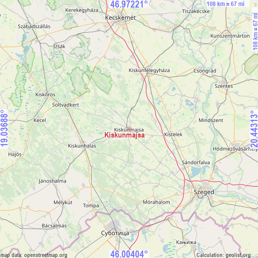
Kiskunmajsa GPS coordinates[2]
46° 29' 25.008" North, 19° 44' 24" East
| Map corner | latitude | longitude |
|---|---|---|
| Upper-left | 46.97221°, | 19.03688° |
| Center: | 46.49028°, | 19.74° |
| Lower-right: | 46.00404°, | 20.44313° |
| Map W x H: | 107.7×107.6 km | = 66.9×66.9mi |
| max Lat: | 48.46667° ⇑86.2% North |
| Kiskunmajsa: | 46.49028° |
| min Lat: | ⇓13.8% South 45.79108° |
| min Long | Kiskunmajsa | max Long |
| 16.27358° | 19.74° | 22.68096° |
| W 55.7%⇐ | ⇒44.3% E |
Elevation
Elevation of Kiskunmajsa is 104 m = 341 ft, and this is 25.7 m = 84 ft below average elevation for this country.
| Max E: |
444 m = 1457 ft | 67.6% |
| Avg. | 129.7 m = 426 ft | |
| Kiskunmajsa | 104 m = 341 ft | |
Min E: |
71 m = 233 ft | 32.4% |
See also: Hungary elevation on elevation.city.
Geographical zone
Kiskunmajsa is located in North temperate zone (between Tropic of Cancer and the Arctic Circle). Distance of this North polar circle is 2231.9 km =1386.8 mi to North.| Distance of | km | miles | from Kiskunmajsa |
|---|---|---|---|
| North Pole | 4837.8 | 3006.1 | to North |
| Arctic Circle | 2231.9 | 1386.8 | to North |
| Tropic Cancer | 2563.3 | 1592.8 | to South |
| Equator | 5169.2 | 3212 | to South |


Nearby cities:
15 places around Kiskunmajsa: (largest is in red/bold)
• Balástya
21.9 km =13.6 mi,  110°
110°
• Bordány
23.7 km =14.7 mi,  143°
143°
• Bugac
22.3 km =13.9 mi,  348°
348°
• Csengele
11.1 km =6.9 mi,  58°
58°
• Forráskút
19 km =11.8 mi, 136°
• Jászszentlászló
8.7 km =5.4 mi,  10°
10°
• Kiskunhalas
20.5 km =12.7 mi,  252°
252°
• Kistelek
18.5 km =11.5 mi,  96°
96°
• Pusztaszer
20.1 km =12.5 mi,  70°
70°
• Pálmonostora
22 km =13.7 mi,  47°
47°
• Ruzsa
22.5 km =14 mi,  178°
178°
• Szank
9.6 km =6 mi,  320°
320°
• Tázlár
18.4 km =11.4 mi,  290°
290°
• Zsombó
25.7 km =16 mi, 135°
• Üllés
18.9 km =11.7 mi,  154°
154°
Sources, notices
• [Note1] Compared only with cities in Hungary existing in our database
• [Src1] Map data: © OpenStreetMap contributors (CC-BY-SA)
• [Src2] Other city data from geonames.org with taken over terms of usage.
• [Src3] Geographical zone / Annual Mean Temperature by Robert A. Rohde @ Wikipedia
