Pilisszentkereszt geodata
Pilisszentkereszt (Pest) is a populated place; located in Hungary in Europe/Budapest (GMT+2) time zone. With population of 2,224 people, there are 702 cities with bigger population in this country. Compared to other cities in Hungary, 70.1% of cities are located further ↓South; 68.6% of cities are located further →East and 99.4% of cities have lower elevation than Pilisszentkereszt. Note1


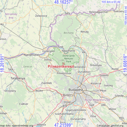
Pilisszentkereszt GPS coordinates[2]
47° 41' 29.148" North, 18° 54' 18.108" East
| Map corner | latitude | longitude |
|---|---|---|
| Upper-left | 48.16257°, | 18.20191° |
| Center: | 47.69143°, | 18.90503° |
| Lower-right: | 47.21599°, | 19.60816° |
| Map W x H: | 105.2×105.2 km | = 65.4×65.4mi |
| max Lat: | 48.46667° ⇑29.9% North |
| Pilisszentkereszt: | 47.69143° |
| min Lat: | ⇓70.1% South 45.79108° |
| min Long | Pilisszentkeres | max Long |
| 16.27358° | 18.90503° | 22.68096° |
| W 31.4%⇐ | ⇒68.6% E |
Elevation
Elevation of Pilisszentkereszt is 335 m = 1099 ft, and this is 205.3 m = 674 ft above average elevation for this country.
| Max E: |
444 m = 1457 ft | 0.59999999999999% |
| Pilisszentkereszt | 335 m 1099 ft | |
| Avg. | 129.7 m = 426 ft | |
Min E: |
71 m = 233 ft | 99.4% |
See also: Hungary elevation on elevation.city.
Geographical zone
Pilisszentkereszt is located in North temperate zone (between Tropic of Cancer and the Arctic Circle). Distance of this North polar circle is 2098.4 km =1303.9 mi to North.| Distance of | km | miles | from Pilisszentkereszt |
|---|---|---|---|
| North Pole | 4704.3 | 2923.1 | to North |
| Arctic Circle | 2098.4 | 1303.9 | to North |
| Tropic Cancer | 2696.9 | 1675.8 | to South |
| Equator | 5302.8 | 3295 | to South |


Nearby cities:
15 places around Pilisszentkereszt: (largest is in red/bold)
• Csobánka
6.6 km =4.1 mi,  139°
139°
• Kesztölc
8.1 km =5 mi,  286°
286°
• Nagykovácsi
9.5 km =5.9 mi,  118°
118°
• Nagymaros
12 km =7.5 mi,  19°
19°
• Pilisborosjenő
11.4 km =7.1 mi, 144°
• Piliscsaba
8.5 km =5.3 mi,  221°
221°
• Piliscsév
6.6 km =4.1 mi,  258°
258°
• Pilismarót
10.6 km =6.6 mi,  347°
347°
• Pilisszentiván
9.1 km =5.7 mi,  182°
182°
• Pilisszántó
2.8 km =1.7 mi,  207°
207°
• Pilisvörösvár
8.6 km =5.3 mi, 178°
• Pomáz
10.7 km =6.6 mi, 120°
• Solymár
11.2 km =7 mi,  169°
169°
• Szentendre
13 km =8.1 mi,  100°
100°
• Visegrád
11.5 km =7.1 mi,  25°
25°
Sources, notices
• [Note1] Compared only with cities in Hungary existing in our database
• [Src1] Map data: © OpenStreetMap contributors (CC-BY-SA)
• [Src2] Other city data from geonames.org with taken over terms of usage.
• [Src3] Geographical zone / Annual Mean Temperature by Robert A. Rohde @ Wikipedia
