Isaszeg geodata
Isaszeg (Pest) is a populated place; located in Hungary in Europe/Budapest (GMT+2) time zone. With population of 10,754 people, there are 158 cities with bigger population in this country. Compared to other cities in Hungary, 57.9% of cities are located further ↓South; 52.1% of cities are located further →East and 88.5% of cities have lower elevation than Isaszeg. Note1


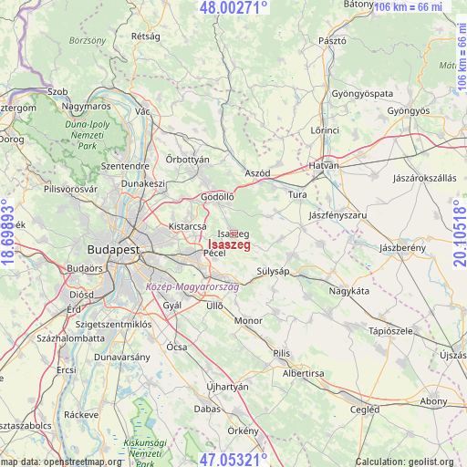
Isaszeg GPS coordinates[2]
47° 31' 48.396" North, 19° 24' 7.38" East
| Map corner | latitude | longitude |
|---|---|---|
| Upper-left | 48.00271°, | 18.69893° |
| Center: | 47.53011°, | 19.40205° |
| Lower-right: | 47.05321°, | 20.10518° |
| Map W x H: | 105.6×105.6 km | = 65.6×65.6mi |
| max Lat: | 48.46667° ⇑42.1% North |
| Isaszeg: | 47.53011° |
| min Lat: | ⇓57.9% South 45.79108° |
| min Long | Isaszeg | max Long |
| 16.27358° | 19.40205° | 22.68096° |
| W 47.9%⇐ | ⇒52.1% E |
Elevation
Elevation of Isaszeg is 182 m = 597 ft, and this is 52.3 m = 172 ft above average elevation for this country.
| Max E: |
444 m = 1457 ft | 11.5% |
| Isaszeg | 182 m 597 ft | |
| Avg. | 129.7 m = 426 ft | |
Min E: |
71 m = 233 ft | 88.5% |
See also: Hungary elevation on elevation.city.
Geographical zone
Isaszeg is located in North temperate zone (between Tropic of Cancer and the Arctic Circle). Distance of this North polar circle is 2116.3 km =1315 mi to North.| Distance of | km | miles | from Isaszeg |
|---|---|---|---|
| North Pole | 4722.2 | 2934.2 | to North |
| Arctic Circle | 2116.3 | 1315 | to North |
| Tropic Cancer | 2678.9 | 1664.6 | to South |
| Equator | 5284.9 | 3283.9 | to South |


Nearby cities:
15 places around Isaszeg: (largest is in red/bold)
• Bag
13 km =8.1 mi,  27°
27°
• Budapest XVII. kerület
12.4 km =7.7 mi,  243°
243°
• Csömör
12.9 km =8 mi,  279°
279°
• Dány
10.7 km =6.6 mi,  96°
96°
• Ecser
11.2 km =7 mi,  211°
211°
• Gyömrő
11.4 km =7.1 mi,  180°
180°
• Gödöllő
8.2 km =5.1 mi,  334°
334°
• Kerepes
9.5 km =5.9 mi,  290°
290°
• Kistarcsa
10.7 km =6.6 mi, 280°
• Maglód
10.1 km =6.3 mi,  196°
196°
• Mende
11.7 km =7.3 mi,  159°
159°
• Nagytarcsa
8.9 km =5.5 mi,  270°
270°
• Pécel
6.4 km =4 mi,  225°
225°
• Valkó
9.1 km =5.7 mi,  65°
65°
• Vácszentlászló
11.3 km =7 mi,  64°
64°
Sources, notices
• [Note1] Compared only with cities in Hungary existing in our database
• [Src1] Map data: © OpenStreetMap contributors (CC-BY-SA)
• [Src2] Other city data from geonames.org with taken over terms of usage.
• [Src3] Geographical zone / Annual Mean Temperature by Robert A. Rohde @ Wikipedia
