Gödöllő geodata
Gödöllő (Pest) is a seat of a second-order administrative division; located in Hungary in Europe/Budapest (GMT+2) time zone. With population of 32,374 people, there are 53 cities with bigger population in this country. Compared to other cities in Hungary, 62.1% of cities are located further ↓South; 53.2% of cities are located further →East and 93.6% of cities have lower elevation than Gödöllő. Note1


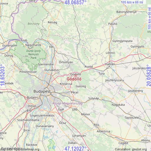
Gödöllő GPS coordinates[2]
47° 35' 47.652" North, 19° 21' 18.54" East
| Map corner | latitude | longitude |
|---|---|---|
| Upper-left | 48.06857°, | 18.65203° |
| Center: | 47.59657°, | 19.35515° |
| Lower-right: | 47.12027°, | 20.05828° |
| Map W x H: | 105.4×105.4 km | = 65.5×65.5mi |
| max Lat: | 48.46667° ⇑37.9% North |
| Gödöllő: | 47.59657° |
| min Lat: | ⇓62.1% South 45.79108° |
| min Long | Gödöllő | max Long |
| 16.27358° | 19.35515° | 22.68096° |
| W 46.8%⇐ | ⇒53.2% E |
Elevation
Elevation of Gödöllő is 210 m = 689 ft, and this is 80.3 m = 263 ft above average elevation for this country.
| Max E: |
444 m = 1457 ft | 6.4% |
| Gödöllő | 210 m 689 ft | |
| Avg. | 129.7 m = 426 ft | |
Min E: |
71 m = 233 ft | 93.6% |
See also: Hungary elevation on elevation.city.
Geographical zone
Gödöllő is located in North temperate zone (between Tropic of Cancer and the Arctic Circle). Distance of this North polar circle is 2108.9 km =1310.4 mi to North.| Distance of | km | miles | from Gödöllő |
|---|---|---|---|
| North Pole | 4714.8 | 2929.6 | to North |
| Arctic Circle | 2108.9 | 1310.4 | to North |
| Tropic Cancer | 2686.3 | 1669.2 | to South |
| Equator | 5292.2 | 3288.4 | to South |


Nearby cities:
15 places around Gödöllő: (largest is in red/bold)
• Aszód
11.1 km =6.9 mi,  56°
56°
• Bag
10.4 km =6.5 mi,  66°
66°
• Csömör
10.5 km =6.5 mi,  240°
240°
• Domony
8.7 km =5.4 mi,  41°
41°
• Erdőkertes
9.2 km =5.7 mi,  337°
337°
• Galgamácsa
11.3 km =7 mi,  12°
12°
• Iklad
9.8 km =6.1 mi, 38°
• Isaszeg
8.2 km =5.1 mi,  154°
154°
• Kerepes
6.8 km =4.2 mi,  233°
233°
• Kistarcsa
8.8 km =5.5 mi, 231°
• Mogyoród
8.6 km =5.3 mi,  270°
270°
• Nagytarcsa
9 km =5.6 mi,  216°
216°
• Szada
5 km =3.1 mi,  324°
324°
• Veresegyház
7.1 km =4.4 mi, 320°
• Őrbottyán
11.4 km =7.1 mi,  331°
331°
Sources, notices
• [Note1] Compared only with cities in Hungary existing in our database
• [Src1] Map data: © OpenStreetMap contributors (CC-BY-SA)
• [Src2] Other city data from geonames.org with taken over terms of usage.
• [Src3] Geographical zone / Annual Mean Temperature by Robert A. Rohde @ Wikipedia
