Kistarcsa geodata
Kistarcsa (Pest) is a populated place; located in Hungary in Europe/Budapest (GMT+2) time zone. With population of 10,986 people, there are 154 cities with bigger population in this country. Compared to other cities in Hungary, 58.9% of cities are located further ↓South; 55.3% of cities are located further →East and 93.1% of cities have lower elevation than Kistarcsa. Note1


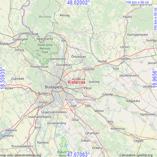
Kistarcsa GPS coordinates[2]
47° 32' 51.252" North, 19° 15' 44.892" East
| Map corner | latitude | longitude |
|---|---|---|
| Upper-left | 48.02002°, | 18.55935° |
| Center: | 47.54757°, | 19.26247° |
| Lower-right: | 47.07083°, | 19.9656° |
| Map W x H: | 105.5×105.5 km | = 65.6×65.6mi |
| max Lat: | 48.46667° ⇑41.1% North |
| Kistarcsa: | 47.54757° |
| min Lat: | ⇓58.9% South 45.79108° |
| min Long | Kistarcsa | max Long |
| 16.27358° | 19.26247° | 22.68096° |
| W 44.7%⇐ | ⇒55.3% E |
Elevation
Elevation of Kistarcsa is 207 m = 679 ft, and this is 77.3 m = 254 ft above average elevation for this country.
| Max E: |
444 m = 1457 ft | 6.9% |
| Kistarcsa | 207 m 679 ft | |
| Avg. | 129.7 m = 426 ft | |
Min E: |
71 m = 233 ft | 93.1% |
See also: Hungary elevation on elevation.city.
Geographical zone
Kistarcsa is located in North temperate zone (between Tropic of Cancer and the Arctic Circle). Distance of this North polar circle is 2114.4 km =1313.8 mi to North.| Distance of | km | miles | from Kistarcsa |
|---|---|---|---|
| North Pole | 4720.3 | 2933.1 | to North |
| Arctic Circle | 2114.4 | 1313.8 | to North |
| Tropic Cancer | 2680.9 | 1665.8 | to South |
| Equator | 5286.8 | 3285.1 | to South |


Nearby cities:
15 places around Kistarcsa: (largest is in red/bold)
• Budapest X. kerület
10.9 km =6.8 mi,  225°
225°
• Budapest XV. kerület
11.1 km =6.9 mi,  278°
278°
• Budapest XVI. kerület
7.8 km =4.8 mi,  242°
242°
• Budapest XVII. kerület
7.5 km =4.7 mi,  184°
184°
• Csömör
2.2 km =1.4 mi, 277°
• Fót
9.6 km =6 mi,  324°
324°
• Gödöllő
8.8 km =5.5 mi,  51°
51°
• Isaszeg
10.7 km =6.6 mi,  100°
100°
• Kerepes
2.1 km =1.3 mi, 47°
• Mogyoród
5.8 km =3.6 mi,  343°
343°
• Nagytarcsa
2.4 km =1.5 mi,  139°
139°
• Pécel
8.8 km =5.5 mi, 137°
• Szada
10.4 km =6.5 mi,  23°
23°
• Veresegyház
11.2 km =7 mi,  12°
12°
• Zugló
12.2 km =7.6 mi,  254°
254°
Sources, notices
• [Note1] Compared only with cities in Hungary existing in our database
• [Src1] Map data: © OpenStreetMap contributors (CC-BY-SA)
• [Src2] Other city data from geonames.org with taken over terms of usage.
• [Src3] Geographical zone / Annual Mean Temperature by Robert A. Rohde @ Wikipedia
