Farád geodata
Farád (Győr-Moson-Sopron) is a populated place; located in Hungary in Europe/Budapest (GMT+2) time zone. With population of 1,936 people, there are 814 cities with bigger population in this country. Compared to other cities in Hungary, 63% of cities are located further ↓South; 95.1% of cities are located further →East and 50.7% of cities have lower elevation than Farád. Note1


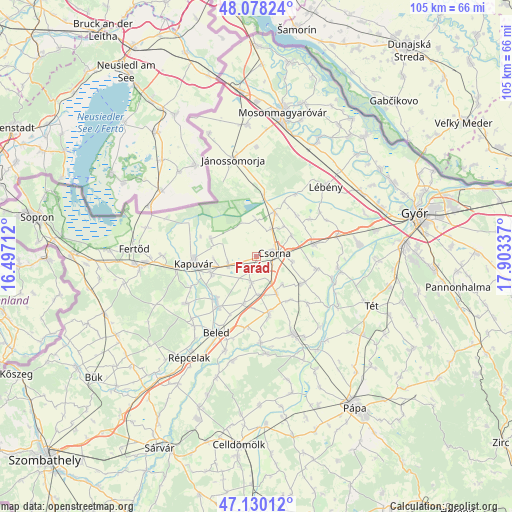
Farád GPS coordinates[2]
47° 36' 22.788" North, 17° 12' 0.864" East
| Map corner | latitude | longitude |
|---|---|---|
| Upper-left | 48.07824°, | 16.49712° |
| Center: | 47.60633°, | 17.20024° |
| Lower-right: | 47.13012°, | 17.90337° |
| Map W x H: | 105.4×105.4 km | = 65.5×65.5mi |
| max Lat: | 48.46667° ⇑37% North |
| Farád: | 47.60633° |
| min Lat: | ⇓63% South 45.79108° |
| min Long | Farád | max Long |
| 16.27358° | 17.20024° | 22.68096° |
| W 4.9%⇐ | ⇒95.1% E |
Elevation
Elevation of Farád is 116 m = 381 ft, and this is 13.7 m = 45 ft below average elevation for this country.
| Max E: |
444 m = 1457 ft | 49.3% |
| Avg. | 129.7 m = 426 ft | |
| Farád | 116 m = 381 ft | |
Min E: |
71 m = 233 ft | 50.7% |
See also: Hungary elevation on elevation.city.
Geographical zone
Farád is located in North temperate zone (between Tropic of Cancer and the Arctic Circle). Distance of this North polar circle is 2107.8 km =1309.7 mi to North.| Distance of | km | miles | from Farád |
|---|---|---|---|
| North Pole | 4713.7 | 2929 | to North |
| Arctic Circle | 2107.8 | 1309.7 | to North |
| Tropic Cancer | 2687.4 | 1669.9 | to South |
| Equator | 5293.3 | 3289.1 | to South |


Nearby cities:
15 places around Farád: (largest is in red/bold)
• Beled
17.6 km =10.9 mi,  207°
207°
• Bősárkány
9.8 km =6.1 mi,  22°
22°
• Csorna
3.8 km =2.4 mi,  81°
81°
• Fertőszentmiklós
24.4 km =15.2 mi,  265°
265°
• Jánossomorja
20.6 km =12.8 mi,  346°
346°
• Kapuvár
12.9 km =8 mi,  263°
263°
• Kisfalud
12 km =7.5 mi,  223°
223°
• Kóny
12.1 km =7.5 mi, 77°
• Lébény
20.3 km =12.6 mi,  44°
44°
• Mihályi
13 km =8.1 mi, 217°
• Mosonszentmiklós
21.7 km =13.5 mi,  51°
51°
• Rábacsécsény
16.9 km =10.5 mi,  97°
97°
• Rábapatona
21.2 km =13.2 mi, 82°
• Rábaszentmihály
17.7 km =11 mi, 100°
• Szany
17.6 km =10.9 mi,  153°
153°
Sources, notices
• [Note1] Compared only with cities in Hungary existing in our database
• [Src1] Map data: © OpenStreetMap contributors (CC-BY-SA)
• [Src2] Other city data from geonames.org with taken over terms of usage.
• [Src3] Geographical zone / Annual Mean Temperature by Robert A. Rohde @ Wikipedia
