Kóny geodata
Kóny (Győr-Moson-Sopron) is a populated place; located in Hungary in Europe/Budapest (GMT+2) time zone. With population of 2,609 people, there are 592 cities with bigger population in this country. Compared to other cities in Hungary, 65% of cities are located further ↓South; 93.4% of cities are located further →East and 54.7% of cities have higher elevation than Kóny. Note1


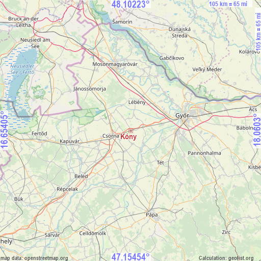
Kóny GPS coordinates[2]
47° 37' 49.908" North, 17° 21' 25.812" East
| Map corner | latitude | longitude |
|---|---|---|
| Upper-left | 48.10223°, | 16.65405° |
| Center: | 47.63053°, | 17.35717° |
| Lower-right: | 47.15454°, | 18.0603° |
| Map W x H: | 105.4×105.4 km | = 65.5×65.5mi |
| max Lat: | 48.46667° ⇑35% North |
| Kóny: | 47.63053° |
| min Lat: | ⇓65% South 45.79108° |
| min Long | Kóny | max Long |
| 16.27358° | 17.35717° | 22.68096° |
| W 6.6%⇐ | ⇒93.4% E |
Elevation
Elevation of Kóny is 113 m = 371 ft, and this is 16.7 m = 55 ft below average elevation for this country.
| Max E: |
444 m = 1457 ft | 54.7% |
| Avg. | 129.7 m = 426 ft | |
| Kóny | 113 m = 371 ft | |
Min E: |
71 m = 233 ft | 45.3% |
See also: Hungary elevation on elevation.city.
Geographical zone
Kóny is located in North temperate zone (between Tropic of Cancer and the Arctic Circle). Distance of this North polar circle is 2105.2 km =1308.1 mi to North.| Distance of | km | miles | from Kóny |
|---|---|---|---|
| North Pole | 4711 | 2927.3 | to North |
| Arctic Circle | 2105.2 | 1308.1 | to North |
| Tropic Cancer | 2690.1 | 1671.6 | to South |
| Equator | 5296 | 3290.8 | to South |


Nearby cities:
15 places around Kóny: (largest is in red/bold)
• Abda
15.8 km =9.8 mi,  63°
63°
• Bősárkány
10.3 km =6.4 mi,  308°
308°
• Csorna
8.3 km =5.2 mi,  255°
255°
• Farád
12.1 km =7.5 mi, 257°
• Győr
21.6 km =13.4 mi,  74°
74°
• Győrszemere
17.7 km =11 mi,  119°
119°
• Kimle
20.8 km =12.9 mi,  1°
1°
• Lébény
12 km =7.5 mi,  12°
12°
• Mosonszentmiklós
12 km =7.5 mi,  26°
26°
• Rábacsécsény
7 km =4.3 mi,  134°
134°
• Rábapatona
9.2 km =5.7 mi,  88°
88°
• Rábaszentmihály
8.2 km =5.1 mi,  136°
136°
• Szany
18.9 km =11.7 mi,  192°
192°
• Tét
16.8 km =10.4 mi, 137°
• Öttevény
13.7 km =8.5 mi,  44°
44°
Sources, notices
• [Note1] Compared only with cities in Hungary existing in our database
• [Src1] Map data: © OpenStreetMap contributors (CC-BY-SA)
• [Src2] Other city data from geonames.org with taken over terms of usage.
• [Src3] Geographical zone / Annual Mean Temperature by Robert A. Rohde @ Wikipedia
