Csopak geodata
Csopak (Veszprém) is a populated place; located in Hungary in Europe/Budapest (GMT+2) time zone. With population of 1,604 people, there are 858 cities with bigger population in this country. Compared to other cities in Hungary, 69.9% of cities are located further ↑North; 86.8% of cities are located further →East and 68.2% of cities have lower elevation than Csopak. Note1


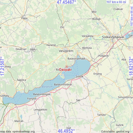
Csopak GPS coordinates[2]
46° 58' 37.524" North, 17° 55' 5.484" East
| Map corner | latitude | longitude |
|---|---|---|
| Upper-left | 47.45467°, | 17.21507° |
| Center: | 46.97709°, | 17.91819° |
| Lower-right: | 46.4952°, | 18.62132° |
| Map W x H: | 106.7×106.7 km | = 66.3×66.3mi |
| max Lat: | 48.46667° ⇑69.9% North |
| Csopak: | 46.97709° |
| min Lat: | ⇓30.1% South 45.79108° |
| min Long | Csopak | max Long |
| 16.27358° | 17.91819° | 22.68096° |
| W 13.2%⇐ | ⇒86.8% E |
Elevation
Elevation of Csopak is 135 m = 443 ft, and this is 5.3 m = 17 ft above average elevation for this country.
| Max E: |
444 m = 1457 ft | 31.8% |
| Csopak | 135 m 443 ft | |
| Avg. | 129.7 m = 426 ft | |
Min E: |
71 m = 233 ft | 68.2% |
See also: Hungary elevation on elevation.city.
Geographical zone
Csopak is located in North temperate zone (between Tropic of Cancer and the Arctic Circle). Distance of this North polar circle is 2177.8 km =1353.2 mi to North.| Distance of | km | miles | from Csopak |
|---|---|---|---|
| North Pole | 4783.7 | 2972.5 | to North |
| Arctic Circle | 2177.8 | 1353.2 | to North |
| Tropic Cancer | 2617.4 | 1626.4 | to South |
| Equator | 5223.4 | 3245.7 | to South |


Nearby cities:
15 places around Csopak: (largest is in red/bold)
• Balatonalmádi
10.1 km =6.3 mi,  50°
50°
• Balatonföldvár
14.1 km =8.8 mi,  191°
191°
• Balatonfüred
3.9 km =2.4 mi,  244°
244°
• Balatonkenese
15.9 km =9.9 mi,  63°
63°
• Balatonszabadi
19 km =11.8 mi,  119°
119°
• Balatonszárszó
17.9 km =11.1 mi,  203°
203°
• Bánd
19.2 km =11.9 mi,  327°
327°
• Hajmáskér
20.2 km =12.6 mi,  22°
22°
• Litér
15.3 km =9.5 mi,  25°
25°
• Nemesvámos
9.3 km =5.8 mi,  339°
339°
• Siófok
13.4 km =8.3 mi,  127°
127°
• Szentkirályszabadja
9.8 km =6.1 mi, 23°
• Tihany
7.4 km =4.6 mi, 197°
• Veszprém
12.9 km =8 mi,  357°
357°
• Zamárdi
10.6 km =6.6 mi,  165°
165°
Sources, notices
• [Note1] Compared only with cities in Hungary existing in our database
• [Src1] Map data: © OpenStreetMap contributors (CC-BY-SA)
• [Src2] Other city data from geonames.org with taken over terms of usage.
• [Src3] Geographical zone / Annual Mean Temperature by Robert A. Rohde @ Wikipedia
