Zamárdi geodata
Zamárdi (Somogy) is a populated place; located in Hungary in Europe/Budapest (GMT+2) time zone. With population of 2,211 people, there are 706 cities with bigger population in this country. Compared to other cities in Hungary, 72.9% of cities are located further ↑North; 86.7% of cities are located further →East and 66.2% of cities have higher elevation than Zamárdi. Note1


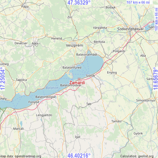
Zamárdi GPS coordinates[2]
46° 53' 5.568" North, 17° 57' 13.176" East
| Map corner | latitude | longitude |
|---|---|---|
| Upper-left | 47.36329°, | 17.25054° |
| Center: | 46.88488°, | 17.95366° |
| Lower-right: | 46.40216°, | 18.65679° |
| Map W x H: | 106.9×106.9 km | = 66.4×66.4mi |
| max Lat: | 48.46667° ⇑72.9% North |
| Zamárdi: | 46.88488° |
| min Lat: | ⇓27.1% South 45.79108° |
| min Long | Zamárdi | max Long |
| 16.27358° | 17.95366° | 22.68096° |
| W 13.3%⇐ | ⇒86.7% E |
Elevation
Elevation of Zamárdi is 105 m = 344 ft, and this is 24.7 m = 81 ft below average elevation for this country.
| Max E: |
444 m = 1457 ft | 66.2% |
| Avg. | 129.7 m = 426 ft | |
| Zamárdi | 105 m = 344 ft | |
Min E: |
71 m = 233 ft | 33.8% |
See also: Hungary elevation on elevation.city.
Geographical zone
Zamárdi is located in North temperate zone (between Tropic of Cancer and the Arctic Circle). Distance of this North polar circle is 2188.1 km =1359.6 mi to North.| Distance of | km | miles | from Zamárdi |
|---|---|---|---|
| North Pole | 4794 | 2978.9 | to North |
| Arctic Circle | 2188.1 | 1359.6 | to North |
| Tropic Cancer | 2607.2 | 1620 | to South |
| Equator | 5213.1 | 3239.3 | to South |


Nearby cities:
15 places around Zamárdi: (largest is in red/bold)
• Balatonalmádi
17.5 km =10.9 mi,  16°
16°
• Balatonföldvár
6.6 km =4.1 mi,  236°
236°
• Balatonfüred
10.6 km =6.6 mi,  324°
324°
• Balatonkenese
20.8 km =12.9 mi,  33°
33°
• Balatonszabadi
14 km =8.7 mi,  85°
85°
• Balatonszárszó
11.6 km =7.2 mi, 237°
• Csopak
10.6 km =6.6 mi,  345°
345°
• Enying
22.5 km =14 mi,  76°
76°
• Nemesvámos
19.9 km =12.4 mi,  342°
342°
• Siófok
8.2 km =5.1 mi,  74°
74°
• Szentkirályszabadja
19.2 km =11.9 mi,  3°
3°
• Tab
18.1 km =11.2 mi,  160°
160°
• Tihany
5.9 km =3.7 mi,  303°
303°
• Zánka
20.5 km =12.7 mi,  265°
265°
• Ádánd
16.3 km =10.1 mi,  100°
100°
Sources, notices
• [Note1] Compared only with cities in Hungary existing in our database
• [Src1] Map data: © OpenStreetMap contributors (CC-BY-SA)
• [Src2] Other city data from geonames.org with taken over terms of usage.
• [Src3] Geographical zone / Annual Mean Temperature by Robert A. Rohde @ Wikipedia
