Veszprém geodata
Veszprém is a seat of a first-order administrative division; located in Hungary in Europe/Budapest (GMT+2) time zone. With population of 62,023 people, there are 31 cities with bigger population in this country. Compared to other cities in Hungary, 66% of cities are located further ↑North; 86.9% of cities are located further →East and 97.8% of cities have lower elevation than Veszprém. Note1


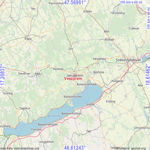
Veszprém GPS coordinates[2]
47° 5' 35.772" North, 17° 54' 41.364" East
| Map corner | latitude | longitude |
|---|---|---|
| Upper-left | 47.56981°, | 17.20837° |
| Center: | 47.09327°, | 17.91149° |
| Lower-right: | 46.61243°, | 18.61462° |
| Map W x H: | 106.5×106.4 km | = 66.2×66.1mi |
| max Lat: | 48.46667° ⇑66% North |
| Veszprém: | 47.09327° |
| min Lat: | ⇓34% South 45.79108° |
| min Long | Veszprém | max Long |
| 16.27358° | 17.91149° | 22.68096° |
| W 13.1%⇐ | ⇒86.9% E |
Elevation
Elevation of Veszprém is 265 m = 869 ft, and this is 135.3 m = 444 ft above average elevation for this country.
| Max E: |
444 m = 1457 ft | 2.2% |
| Veszprém | 265 m 869 ft | |
| Avg. | 129.7 m = 426 ft | |
Min E: |
71 m = 233 ft | 97.8% |
See also: Veszprém elevation on elevation.city.
Geographical zone
Veszprém is located in North temperate zone (between Tropic of Cancer and the Arctic Circle). Distance of this North polar circle is 2164.9 km =1345.2 mi to North.| Distance of | km | miles | from Veszprém |
|---|---|---|---|
| North Pole | 4770.8 | 2964.4 | to North |
| Arctic Circle | 2164.9 | 1345.2 | to North |
| Tropic Cancer | 2630.4 | 1634.5 | to South |
| Equator | 5236.3 | 3253.7 | to South |


Nearby cities:
15 places around Veszprém: (largest is in red/bold)
• Balatonalmádi
10.5 km =6.5 mi,  127°
127°
• Balatonfüred
14.9 km =9.3 mi,  191°
191°
• Balatonkenese
15.9 km =9.9 mi,  111°
111°
• Berhida
16.6 km =10.3 mi,  83°
83°
• Bánd
10.4 km =6.5 mi,  288°
288°
• Csopak
12.9 km =8 mi,  177°
177°
• Hajmáskér
10 km =6.2 mi,  54°
54°
• Herend
13 km =8.1 mi, 290°
• Litér
7.1 km =4.4 mi, 83°
• Nemesvámos
5.1 km =3.2 mi,  213°
213°
• Pétfürdő
17.5 km =10.9 mi,  62°
62°
• Szentkirályszabadja
6 km =3.7 mi, 131°
• Tihany
20 km =12.4 mi, 184°
• Zirc
19.2 km =11.9 mi,  351°
351°
• Úrkút
20.3 km =12.6 mi,  267°
267°
Sources, notices
• [Note1] Compared only with cities in Hungary existing in our database
• [Src1] Map data: © OpenStreetMap contributors (CC-BY-SA)
• [Src2] Other city data from geonames.org with taken over terms of usage.
• [Src3] Geographical zone / Annual Mean Temperature by Robert A. Rohde @ Wikipedia
