Siófok geodata
Siófok (Somogy) is a seat of a second-order administrative division; located in Hungary in Europe/Budapest (GMT+2) time zone. With population of 23,028 people, there are 73 cities with bigger population in this country. Compared to other cities in Hungary, 72.4% of cities are located further ↑North; 85.1% of cities are located further →East and 63.9% of cities have higher elevation than Siófok. Note1


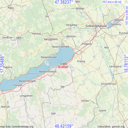
Siófok GPS coordinates[2]
46° 54' 14.868" North, 18° 3' 28.8" East
| Map corner | latitude | longitude |
|---|---|---|
| Upper-left | 47.38237°, | 17.35488° |
| Center: | 46.90413°, | 18.058° |
| Lower-right: | 46.42159°, | 18.76113° |
| Map W x H: | 106.8×106.8 km | = 66.4×66.4mi |
| max Lat: | 48.46667° ⇑72.4% North |
| Siófok: | 46.90413° |
| min Lat: | ⇓27.6% South 45.79108° |
| min Long | Siófok | max Long |
| 16.27358° | 18.058° | 22.68096° |
| W 14.9%⇐ | ⇒85.1% E |
Elevation
Elevation of Siófok is 107 m = 351 ft, and this is 22.7 m = 74 ft below average elevation for this country.
| Max E: |
444 m = 1457 ft | 63.9% |
| Avg. | 129.7 m = 426 ft | |
| Siófok | 107 m = 351 ft | |
Min E: |
71 m = 233 ft | 36.1% |
See also: Hungary elevation on elevation.city.
Geographical zone
Siófok is located in North temperate zone (between Tropic of Cancer and the Arctic Circle). Distance of this North polar circle is 2185.9 km =1358.3 mi to North.| Distance of | km | miles | from Siófok |
|---|---|---|---|
| North Pole | 4791.8 | 2977.5 | to North |
| Arctic Circle | 2185.9 | 1358.3 | to North |
| Tropic Cancer | 2609.3 | 1621.3 | to South |
| Equator | 5215.3 | 3240.6 | to South |


Nearby cities:
15 places around Siófok: (largest is in red/bold)
• Balatonalmádi
14.9 km =9.3 mi,  349°
349°
• Balatonföldvár
14.6 km =9.1 mi,  246°
246°
• Balatonfüred
15.5 km =9.6 mi,  294°
294°
• Balatonkenese
15.6 km =9.7 mi,  13°
13°
• Balatonszabadi
6.1 km =3.8 mi,  100°
100°
• Balatonszárszó
19.6 km =12.2 mi,  244°
244°
• Csopak
13.4 km =8.3 mi,  307°
307°
• Enying
14.3 km =8.9 mi,  78°
78°
• Lepsény
17 km =10.6 mi,  55°
55°
• Nemesvámos
21.8 km =13.5 mi,  320°
320°
• Szentkirályszabadja
18.3 km =11.4 mi,  338°
338°
• Tab
19.3 km =12 mi,  185°
185°
• Tihany
12.9 km =8 mi,  274°
274°
• Zamárdi
8.2 km =5.1 mi, 254°
• Ádánd
9.5 km =5.9 mi,  121°
121°
Sources, notices
• [Note1] Compared only with cities in Hungary existing in our database
• [Src1] Map data: © OpenStreetMap contributors (CC-BY-SA)
• [Src2] Other city data from geonames.org with taken over terms of usage.
• [Src3] Geographical zone / Annual Mean Temperature by Robert A. Rohde @ Wikipedia
